StudentShare
Contact Us
Sign In / Sign Up for FREE
Search
Go to advanced search...
Free

Hunslet Riverside Overview - Essay Example

Cite this document
Summary
This essay "Hunslet Riverside Overview" focuses on the Hunslet River has four character sites namely; Area 2A- Copperfields, Area 2B- Knowsthorpe, Area 2C- Hunslet Riverside South, and Area 2D- National Road. The character area is also set apart for strategic housing…
Download full paper File format: .doc, available for editing
GRAB THE BEST PAPER92.2% of users find it useful
Hunslet Riverside Overview
Read Text Preview

Extract of sample "Hunslet Riverside Overview"

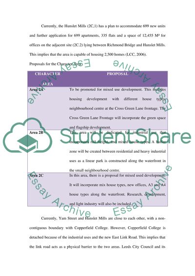
Character Area 2 - Hunslet Riverside 2.0 Character Area 2 - Hunslet Riverside Overview The Hunslet River has four character sites ly; Area 2A- Copperfields, Area 2B- Knowsthorpe, Area 2C- Hunslet Riverside South and Area 2D- National Road. The character area also set apart for “Strategic Housing and Mixed Use Development Site” according to the UDP (LCC, 2007) is found on the southern side of South Accommodation Road. The Hunslet Riverside covers the river side, engulfs the Hunslet Mills Complex, a historic site. It also covers Yarn Street found on the southern side of the Hunslet River as well as the Knowsthorpe site and the famously known Copperfield College towards the north (LCC, 2006). A railway line branch ends at the Tarmac site and the aggregate operations area demarcates Copperfields and the Knowsthorpe site. Currently, the Hunslet Mills (2C,1) has a plan to accommodate 699 new units and further application for 699 apartments, 335 flats and a space of 12,455 M² for offices on the adjacent site (2C.2) lying between Richmond Bridge and Hunslet Mills. This implies that the area is capable of housing 2,500 homes (LCC, 2006). Proposals for the Character Area CHARACTER AREA PROPOSAL Area 2A To be promoted for mixed use development. This includes housing development with different house types, neighbourhood centre at the Cross Green Lane frontage. The Cross Green Lane Frontage will incorporate the green space and flagship development. Area 2B This area will be dedicated for industrial use that incorporates rail freight, and mixed house types. A buffer zone will be created between residential and heavy industrial uses as a linear park is constructed along the waterfront in the small neighbourhood centre. Area 2C In this area, there is a proposal for mixed used development. It will incorporate mix house types, new offices, A3 and A4 house types along the waterfront. Research, development, and light industry will also be included. Currently, Yam Street and Hunslet Mills are close to each other, with a non-contiguous boundary with Copperfield College. However, Copperfield College is detached because of the industrial uses and the new East Link Road. This implies that the link road acts as a physical barrier to the two areas. Leeds City Council and its partners require development proposals that progress progressively in terms of quality with surrounding land uses and with the Yarn Street site. Fruitful negotiations with landowners concerning the level of funding from the public sector as proposed by the proposal must ensure that the scheme is viable. The discussed sites present development opportunities worth exploration but still there arises some issues that need to be accounted for. These are; • The development deems successful through small scale retail development schemes. • The character area needs crucial levels of remediation to areas that are contaminated. • The proposed industrial units should offer employment opportunities to local residents emerging from marginalised communities. On the other hand the local marginalised people should have work experience training and relevant skills required. • The area needs a new river crossing although it is not necessary for several years. • Sustainable forms of transport such as road network should be accessible to Yorkshire Forward development. • An effective infrastructure grid that creates a strong link between the southern and northern links. • The area needs quality public transport, cycle and pedestrian routes to contain the increasing city council population. • An extensive cycle path network is required in the whole area. • The filter beds at Knosthrope Waste Water Treatment Plant require extra effort for removal. • Better designs that empower investors with improved landscaping and open spaces are of importance. • Flooding and contaminated land issues need mitigation. • Waste in the area poses great challenges to green environment. Sustainable waste management solutions are needed. • Beauty is an important aspect in a city. This means that reputational images need to improve the city council. • Delivery vehicle for the area must be creative and effective to ensure a successful implementation of development proposals. 2.1 Summary of major infrastructure and environmental issues 2.1.1 Geotechnical issues Areas with significant volume changes in soil need to be tested and verified. Since the area is close to the river, high chances of high water table exist. The ground is likely to be contaminated due to massive environmental pollution and therefore tests are required for ground contamination 2.1.2 Hydrological issues River Aire may experience floods during high river levels. Therefore flood defences along the river are necessary to curb overtopping. Area 2C is situated along high risk flood zone. 2.1.3 Structural issues Since structures will be erected along the riverside, piles are needed. The area is likely to have low ground bearing capacity and therefore the slab should be thickened at the edges for better bearing structures. 2.1.4 Infrastructure issues Area 2A especially Cross Green has poor conditions and lack facilities. Access roads to Sites 2A.1 and 2B.1 need to be improved to comply with public transport accessibility needs. Once the access road is upgrade to Hunslet DC, Site 2B.1 would be a beneficiary. The North bank of River Aire lack a walking and cycling route. Packing facilities are not available in the area. The area requires water sewerage, storm water, gas, electricity and telephone (telecommunication services) services. The HGV in Area 2B and Knowsthorpe require a new vehicle access. Since the area has no river crossing, it must be incorporated in the proposal. River transportation is required in the area to improve accessibility. 2.1.5 Environmental issues Since the area is prone to floods, flood defence mechanisms need to be installed to reduce the adverse effects of floods. Air pollution Petro-chemical industries occupying the site around Area 2B lead to ground contamination. Ground contamination leads to other aspects of pollution such as water pollution. Sites such as 2C.1 to 2C5, and 2B.1 face high risks of flooding. The railway line poses a threat to noise pollution. 2.1.6 Highway issues The area lacks walking and cycling paths Effective public transport for the area needs more links than the existing ones 2.1.7 Health and Safety issues There are high chances of falling and drowning into the river since there are no safety measures along the river. Construction projects will make ELLR busy which at the same time poses some danger to the people. Sewerage treatment works emit leptospirosis, a health hazard to residents. Contaminated land increases poisoning chances to locals. The workers get exposed to poisonous asbestos fibres which are a health hazard to them. Construction projects are related to accidents from machinery used. This means that safety in the working area is essential. Character Area 5 - Thorne Farm & Skelton Moor Farm 5.0 Thorne Farm & Skelton Moor Farm At the proximity Knostrop EETW is Character Area 5, thinly separated by the East Leeds Link Road. The area has six sites; 5A1-5A.5 and 5B.1. CHARACTER AREA DEVELOPMENT PROPOSAL 5A.1 This area is set aside for research and development industry 5A.2-5A.5 These sites are proposed for general industry or warehouse development 5B.1 This is the largest site in the area and is set aside for mixed-use development The area has an unpleasant view from the waste water treatment works and East Leeds Link road. Previous efforts of mitigating air pollution from the waste water treatment works has not bore fruits to the area. The odour remains unbearable. Unsuccessful efforts such as enclosing the WWTW facilities in a single building, screening, planting trees aim at softening the impact of ELLR and reducing the odour nuisance. Fortunately, the ELLR is located next to the site. This implies that access to this site is not a problem. The development proposals should capture the adjoining communities, the impact of the development projects to the community in terms of air pollution, water pollution, among other forms of health hazards. The East Leeds link Road will be very busy due to increased activities in the area. This will mean that the solution towards crossing of the road will be needed. On the other hand, the sites do not meet accessibility requirements for public transport. The development proposal must consider infrastructure needs so that development project proposals for the area are supported. At the same time, the area is prone to flooding as depicted in the Figure 1.0.1. This implies that the development proposals must capture flood mitigation measures. The character area is prone to flooding, as shown in Figure 1.0.1 5.1 Summary of major infrastructure and environmental issues 5.1.1 Infrastructure issues Public transport accessibility is vital for any development. Therefore accessibility improvements are necessary for Sites 5A.1, 5A.2, 5A.3, 5A.4, 5A.5 and 5B.1. Local services and facilities should not be cut off from the development projects and therefore they should accessible. Air pollution, noise pollution, and water pollution will emanate from ELLR. The northern boundary requires a 40 metre long. The northern and western boundaries require a Bus gate. 5.1.2 Environmental issues Mitigation issues are required for the noise emitted from the East Leeds Link Road. The environs of the character area are prone to noise and pollution. The area is prone to flooding during the rainy season. 5.1.3 Highway issues As traffic increases in the area, so is congestion increased. Congestion causes pollution to the environment. Upgrading of the existing roads is necessary so that traffic congestion is eased. A vivid example is that of the Clarence road area and Crown Point Bridge. Failure to expand these roads will lead to massive traffic congestion during the construction phase. 5.1.4 Health and Safety issues The East Leeds Link Road remains a busy road that requires a new method crossing. ELLR area will require noise mitigation measures. Odour produced from the waste water unit is a nuisance to the area and a rapid mitigation measures are required. Accidents from the ongoing construction projects are inevitable. Character Area 7 - Thwaite Mills 7.0 Character Area 7 - Thwaite Mills Overview Proposal developments for Thwaite Mills include relocation of Trans Pennine route, developing recreational sites, and increasing the links between Skelton Grange environmental centre and Thwaite Mills. Thwaite Mills is located in the midst of two rivers; the River Aire and River Calder. Issues of accessibility and highway links are of concern as Thwaite Mills is situated in the middle of two rivers, the River Aire and the River Calder. Such a position hampers transportation of materials to site and will involve extra costs to constructing companies. The companies will need to construct temporary access roads to be used by vehicles and machinery. Care is needed by construction companies when selecting machineries for use during the project construction phase. Areas such as narrow banks, steep slopes, definition of hauling routes, and turning points for limited space areas provide little margins for errors and are worth consideration during the planning stage. Poor road network and lack of links cannot support development. Therefore connectivity in the area can be achieved through design of core roads and rail links. The river can also be used to establish connectivity and support development projects. This is a viable short-term option for Thwaite Mills but a long-term option for recreational purposes. On the other hand, provision of bridges fro vehicles and footbridges for residents will solve accessibility challenges brought by the two rivers. At the same time, Visual impact of the area will be improved. Development projects in the area need to incorporate a smooth transition and blending of the landscape, structures and the natural landscape. Important assets for the area such as the river corridor and historical buildings must be captured. Slope failure is common in Thwaite Mills. For example, the March 1998 flooding of Thwaite Mills was as a result of slope failure. This issue need to be well addressed since it is a concern to designers and developers. Intensive site investigation is necessary so that viable options are explored. Environmental and biodiversity considerations in this area such as preservation of historical monuments (mill and the museum), incorporation of sustainable drainage systems (SUDS), enhancing the air quality as the area is near Knostrop sewage treatment works, minimising water, noise and land pollution and the implementation of flood defences are important. Since the area is prone to flooding by the Knostrop WWTW, mitigation measures remain inevitable. A viable solution will be derived from identifying sewer flooding problems. The relevant authorities such as environmental bodies can be invited to offer possible solutions. The solutions sought for in the development strategy need to be tested against high flow possibilities through the hydraulic models of rivers. Other opportunities that exist for collaborative schemes for alleviating floods from the river and WWTW need to be explored. Proper infrastructure is also required in place to support development in the area. 7.1 Summary of major infrastructure and environmental issues 7.1.1 Infrastructure issues Since the Sites 7.1 and 7.2 are inaccessible, improvements that comply with public transport accessibility is important. Sites 7.1 and 7.2 need to be connected with a new bridge since they are not linked Local services and facilities are inaccessible. They should be easily accessed by the locals. Site 7.2 has recreational potential from the river and there is need to unlock this potential. 7.1.2 Environmental issues Mitigation measures for noise pollution from East Leeds Link Road are needed. Mitigation measures towards noise and pollution in the surrounding areas is vital. Flooding challenges from overflowing river during rainy season. 7.1.3 Health and Safety issues Safety measures for crossing the East Leeds Link Road needs to be deployed. Power cables can be exposed to fire. Noise mitigation measures required for ELLR The WWTW requires better noise reduction measures Health and safety issues linked to construction industry must be looked at Character Area 8 - Stourton Corridor 8.0 Character Area 8 - Stourton Corridor Overview In the south east of Aire Valley Leeds regeneration area is found the Stourton Corridor with nine development sites: Areas 8.1-8.9. Proposal developments for the area captures mixed employment development for site 8.1 and employment development that excludes offices for sites 8.2 to 8.4 and sites 8.6 to 8.9. Site 8.5 will incorporate a new park/amenity area, located on the flowery existing ponds off Haigh Park Road. This is a high quality land mark development for this site. A new railway station will be constructed on the Leeds- Castleford line. The new railway line for Leeds-Castleford line will offer brand opportunities for the proposed area. The station will also provide access to employment areas while offering no threats to pedestrians and cyclists. The construction ground for the railway station needs thorough investigation for suitability purposes. Figure 1.0.3 shows previous and present landfill sites in the areas. Construction of park/amenity area around the ponds on Haigh Park Road triggers many environmental benefits to the area such as encouraging fauna and flora. The area will be free from noise since it will be free from traffic. At the same time, the preserved green space will contribute to green environment that reduces carbon emissions by serving as carbon sinks. High pollution levels due to waste is indicated by blue squares in Figure 1.0.3, with a few areas of major pollution as indicated by the red triangles. This implies that the area has great potential for developmental opportunities such as recreational areas, green space, habitat creation and river development for restaurants. Generally, sites 8.6, 8.7. 8.8 and 8.9 comply with public transport accessibility requirement while sites 8.1, 8.2, 8.3. 8.4 and 8.5 do not. Therefore public transport infrastructure requirements for the latter sites need to be addressed. 8.1 Summary of major infrastructure and environmental issues 8.1.1 Infrastructure issues Upgrade of public transport access roads to Sites 8.1, 8.2, 8.3, 8.4 and 8.5 is needed. The area lacks walking and cycling routes Water sewerage, storm water, gas, electricity and telephone (Telecommunication services) are substandard and need to be improved Local services as well as facilities should be accessible. 8.1.2 Environmental issues Mitigation measures for reducing noise emissions from the East Leeds Link Road required The environs of the area will be exposed to noise and pollution Floods are likely to occur during the rainy season 8.1.6 Health and Safety issues Odour nuisance from the WWTW should be controlled. Construction related health & safety issues cannot be evaded. Character Area 11 - Skelton Business Park 11.0 Character Area 11 - Skelton Business Park This is a 72 area site which located to the south east of the M1 motorway which separates it from the rest of the Aire Valley Leeds regeneration area. Proposal development plans for the area includes; construction of a Skelton Business Park for the small community. The park will have residential and office buildings with a small centre. The area is close to River Aire, a lake, and adjacent to M1 motorway. Since it is located on a flood plain, the area risks high flooding. The area stands close to M1 and therefore exposed to noise and dust/pollution. This is a major concern for the area and viable options of mitigating this form of pollution must be explored. A probable solution is planting of a tree screen along the motorway. This will reduce noise, pollution, and visual impact. The noise can be controlled by construction of a barrier along the motorway to buffer noise intensity. The M1 cuts off the site from the surrounding communities and an underground bridge for safe pedestrian crossing must be constructed over the M1. This will improve pedestrian safety and accessibility of the other side of the motorway. An introduction of sidewalks in the area will allow a safe passage when walking in the area. Initially, the site was an open cast mine and so the soil in the area could be contaminated. This implies that remediation is required; a strategy that will affect new built structures. 11.1 Summary of major infrastructure and environmental issues 11.1.1 Geotechnical issues Since the area was an open cast mine area, geotechnical risk appraisal is needed. 11.1.2 Infrastructure issues Accessibility is required for development and therefore accessibility to Sites 11A.1, 11B.1 and11C.1 need be improved. Local services and facilities should not be cut off hence they should be accessed The area lacks walking and cycling route Upgrading of the highway is needed to Junction 45 Recreational facilities such as Temple Newsam and Rothwell Country Park need to be linked by cycle and footpath Noise mitigation measures are required Structural landscaping scheme that is appropriate is needed 11.1.3 Environmental issues Noise and pollution from the construction projects will be a menace to the surrounding areas Odour from WWTW remains a menace and should be controlled 11.1.4 Highway issues Increased traffic in the area leads to congestion and other environmental problems. Upgrading of the roads is necessary to provide ideal transport that eases traffic congestion. The Crown Point Bridge need to be developed so that the Clarence road area can be fully accessed. Such a strategy will ease traffic congestion during the construction phase. 11.1.4 Health and Safety issues Noise mitigation measures required for M1 and M621 Further odour reduction required WWTW Health & safety related accidents Reference List Leeds City Council (2006). Aire Valley Leeds Area Action Plan [Online] Available at: http://www.leeds.gov.uk/docs/FPI_AVL_ALT%20001%20Alternative%20Optio %20Document.pdf. [Accessed: 2/3/14] Leeds City Council (2007). Aire Valley Leeds Area Action Plan, Development Plan Document, Sustainability Appraisal Report. [Online] Available at: http:// http://www.leeds.gov.uk/docs/FPI_AVL_008%20Sustainability%20Appraisal%20R port.pdf. [Accessed: 2/3/14]. Read More
Cite this document
  • APA
  • MLA
  • CHICAGO
(“Project Report Essay Example | Topics and Well Written Essays - 3000 words - 1”, n.d.)
Project Report Essay Example | Topics and Well Written Essays - 3000 words - 1. Retrieved from https://studentshare.org/engineering-and-construction/1627241-project-report
(Project Report Essay Example | Topics and Well Written Essays - 3000 Words - 1)
Project Report Essay Example | Topics and Well Written Essays - 3000 Words - 1. https://studentshare.org/engineering-and-construction/1627241-project-report.
“Project Report Essay Example | Topics and Well Written Essays - 3000 Words - 1”, n.d. https://studentshare.org/engineering-and-construction/1627241-project-report.
  • Cited: 0 times

CHECK THESE SAMPLES OF Hunslet Riverside Overview

Exotic Settings and Motifs in the Poetry of the British Romantic Period

This paper 'Exotic Settings and Motifs in the Poetry of the British Romantic Period' tells that the exotic settings of the romantic period have come from the 'romantic orientalism' where the letters, poems, and prose play upon the ideas enveloped by the notion of 'romantic orientalism.... .... ... ...
9 Pages (2250 words) Research Paper

Tech-Rich Riverside

Local Tech-Rich riverside What is the "Digital Divide"?... 2-How has the "Wireless riverside" project helped to decrease the Digital Divide among riverside residents?... -What is the Digital Inclusion program, and how has it helped riverside residents?... nswer:Digital Inclusion program is a program started by riverside with the aiming low-income residents to be taught computer skills and providing them with refurbished computers at no cost....
1 Pages (250 words) Article

City of Riverside Waste Management

As the paper "City of riverside Waste Management" tells, riverside was designated an American city in 1998.... The riverside city council worked closely with the county and waste subcontractors in meeting its waste diversion responsibility.... riverside County's main city is the city of riverside.... The department of public works in the city of riverside provides solid waste collection services in the city....
8 Pages (2000 words) Essay

Conflict between the Management and the Employees of Riverside Hotel

In the paper 'Conflict between the Management and the Employees of riverside Hotel,' the author discusses the source of conflict between the management and the employees, which is the costs the employees incur as a result of their taking dinner at the hotel on the late shift.... The source of conflict between the management and the employees of riverside Hotel is the costs the employees incur as a result of their taking dinner at the hotel on the late shift (Jiambalvo Case study 1)....
8 Pages (2000 words) Case Study

The California-Riverside Community Garden

The paper "The California-riverside Community Garden" describes that the garden has numerous plots ready for use by either the community members or students.... Notably, the riverside region in California has a history of rigorous real estate activities.... The California-riverside community is one of the regions that experienced numerous adverse effects of the economic crisis....
5 Pages (1250 words) Essay

St. Johns Riverside Hospital- Health Information Management

John's riverside Hospital- Health Information Management.... Saint John's riverside Hospital has not only been recognized for achieving this but also awarded for providing available, effective and innovatively propelled social insurance to the society.... Patients who have left Saint John's riverside Hospital have given it an overall rating of 70% according to health grades.... John's riverside Hospital had used a traditional infrastructure with regard to patient database and storage space....
3 Pages (750 words) Essay

A Written Episode from Social Practice at Riverside House

This paper ''A Written Episode from Social Practice at riverside House '' tells that The scope of this paper is to the dynamics of volunteer programs and exercises.... As already mentioned, riverside House is one of the Salvation Army centers that provide social services in London.... For one, as a project worker at the riverside House, I have to work closely with the patients, right from the point of referral right through to resettlement.... This, in turn, makes assisting these service users to utilize basic life-skills which they may have acquired throughout their stay in the riverside House....
6 Pages (1500 words) Report

Parking Space Problem at the University of California, Riverside

The paper "Parking Space Problem at the University of California, riverside " highlights that the University Of California, riverside should reduce the cost of parking within its premises to provide convenience for students staying outside the campus hostels.... This paper, therefore, explores the state of the parking problem at the University of California, riverside (UCR) in addition to providing possible ways of improving the situation.... he University of California, riverside (UCR) is an ideal institution of higher education because it provides an environment that is conducive for learning....
5 Pages (1250 words) Essay
sponsored ads
We use cookies to create the best experience for you. Keep on browsing if you are OK with that, or find out how to manage cookies.
Contact Us