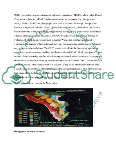
StudentShare
Contact Us
Sign In / Sign Up for FREE
Search
Go to advanced search...
Free

Use of Remote Sensing for Development by the Indian Space Research Organization (ISRO) - Essay Example

Cite this document
Summary
This essay explores the role that has been played by the Indian Space Research Organization (ISRO) in the use of remote sensing for development. ISRO is involved in research and development in a number of fields including weather monitoring, disaster management, geospatial information science…
Download full paper File format: .doc, available for editing
GRAB THE BEST PAPER92.1% of users find it useful
Use of Remote Sensing for Development by the Indian Space Research Organization (ISRO)
Read Text Preview

Extract of sample "Use of Remote Sensing for Development by the Indian Space Research Organization (ISRO)"

Use of Remote Sensing for Development by the Indian Space Research Organization (ISRO) Introduction The Indian Space Research Organization (ISRO) is a body mandated with bringing the space to the common man as an act of national service. It was formed in 1969 and today it has grown to become one of the biggest national space agencies globally. It commands one of the world’s largest fleet of communication satellites and remote sensing satellites (Kaur et al, 2005). This enables it to cater for the growing demand for infrastructural networks in communication technology and national development. The Indian Space Research Organization (ISRO) is involved in research and development in a number of fields including: weather monitoring, cartography, disaster management, geospatial information science, navigation and education. This research will explore the role that has been played by the Indian Space Research Organization (ISRO) in the use of remote sensing for development. Discussion National development normally requires a comprehensive survey of the available natural resources in a country. This will help to optimize the management and sustainability of the available resources by making use of the strengths of remote sensing (Navalgund et al, 2007). India as a country has embraced remote sensing in development activities through various institutions such as the Indian Space Research Organization (ISRO) in various fields such as agriculture, water resources management, management of forests and ecosystems, climate change and urban planning. These areas in which ISRO has employed the use of remote sensing for development activities are as discussed below. Agriculture Agriculture normally supports 60 % of the total population of India and normally contributes about 2.5 % of the gross domestic product (GDP) of the country. Remote sensing techniques have been extensively used as a tool for improvement on crop production by providing solutions for the current problems. A joint operation between the Indian Space Research Organization (ISRO) , Agriculture resources inventory and survey experiment (ARISE) and the Indian Council of Agricultural Research (ICAR) has been used to forecast the production of crops in the country. Aerial color infrared photographs were used to estimate the acreage of crops in the district of Anatpur and in Patiala district of Punjab (Navalgund et al, 2007). In the year 1986, a project referred to as the crop acreage and production estimation was created under the umbrella of remote sensing application missions. The CAPE project provided district level forecast of production of all the major crops in India including: Wheat, rice, sorghum, cotton and groundnuts. The acreage of land under each crop was estimated using satellite imagery obtained using remote sensing techniques. The CAPE project evolved into the Forecasting agricultural output space agro meteorology and land based observations (FASAL) which put together various methods of remote sensing together with all the organizations involved in order to come up with a hierarchical system for information management (Kshama & Sadhana, 2005). The optimization of FASAL has led to the establishment of a research facility called Mahalanobis national crop forecast center. Using remote sensing techniques, the agro ecological zones have been identified through analytical methods on the Doon valley. Analytical maps have been developed using integrated agro climate data and map layers of agro edaphic zones. Figure 1: Agricultural zones in the Doon valley Management of water resources There is a great need to have accurate and reliable information about the availability and the quality of water. The Indian Space Research Organization (ISRO) has engaged in the use of remote sensing to map the watersheds and relate them to the soils in those areas for development purposes. The development of watersheds normally involves activities such as characterization of the existing landmass, prioritization of the selected area for analysis, generation of an action plan, creation of a watershed, implementation of the plan for the watershed and monitors the expected impact from the project (Patkar, 2005). The Indian Space Research Organization (ISRO) has developed watersheds for 175 districts in the country under the watershed development plan of integrated mission for sustainable development (IMSD). The development of watersheds has resulted into increased crop production in many of these districts. The study in Shera proposed the construction of check dams and after the implementation of this proposal, there was a substantial increase in the production of Kharifa, rabi and the revenue collected by the farmers increased. Remote sensing has also been used to analyze the terrain and propose areas that require irrigation. A study conducted by the Indian Space Research Organization (ISRO) in the Mahi Right bank canal showed that the area is faced with problems of waterlogging, salinity and urbanization. Using the analytical information obtained, the soil degradation was reduced substantially to manageable levels (Patkar, 2005). Figure 2: watershed alignment in the Doon valley Management of forests and the eco system Forests remain an important natural resource in India since they act as a major determinate factor of the environmental conditions in the conditions hence influencing agriculture and the food security. The first remote sensing based mapping at national level was carried out in the country in 1983. Since then, the survey of forest is normally done biennially. The Indian Space Research Organization (ISRO) in liaison with the ministry of environment and forests conducted a study of the encroachment of the Sanjay Gandhi National park in Mumbai. Using multi temporal satellite data, they were able to monitor and map the grasslands of Banni Kachchh and hence come up with measures to mitigate the impacts of this encroachment. The two bodies have also engaged in mapping of the wetlands of India including the Himalayas where about 126249 hectares of land were mapped and the conservation of the forests in the North east, the Western Ghats and Central India. This has helped to reduce degradation of the forests and maintain a balance in the eco system. Figure 3: forests cover in the Behta block Monitoring of climate change Climate change is a global problem and as a result, it impacts on the agricultural land, sea levels, energy and water resources. The Indian Space Research Organization (ISRO) initiated the programme on climate change research in terrestrial environment (PRACRITI) which studies the impacts of climate change in the country (Sudhir, 2003). This programme has been able to monitor the inventory of methane released from paddies of rice and the livestock, the impact of climate change on agriculture and to model the run off of water in the country. Urban planning India is a country that has one of the highest populations in the world and hence there is a great need to monitor the development of urban areas in the country. ISRO in partnership with local authorities has been able use remote sensing techniques to handle some complex problems that are related to development. By using base maps, photogrammetric images and satellite imagery, urban planimetric maps have been developed (Rahman, 2006). An example of such a project was conducted in the city of Mumbai in partnership with the local council. Urban sprawl had been noted to be a big challenge in this region and the local authorities needed a planimetric map for development of this area (Sudhir, 2003). The pattern of the hydrologic network of the city including water supply lines, drainage lines for both sewage and run off were mapped, the available infrastructural networks and utilities lines were mapped, traffic situations were mapped and the waste disposal areas mapped too. This data was used to develop a planimetric map for the city to accommodate the growing population. Figure 4: Planimetric map of central Mumbai Conclusion From the discussions above, it is evident that remote sensing is a strong tool for national development. The relevant government institutions that are mandated with the development of various sectors of the economy can liaise with the institutions involved with remote sensing research activities in order to get a comprehensive and effective way of achieving development in their fields of focus. References Kaur Amarjeet, Dutta Venkatesh, Chaddha D. K. (2003), “Application of Remote Sensing and GIS tools in delineating Environmentally-Fragile-Areas (EFAs) for sustainable land use planning: A case study of Delhi Region”, Proceedings of the Gap India Conferences. Kshama Gupta, Sadhana Jain, (2005), “Enhanced capabilities of IRS P6 LISS IV sensor for urban mapping”, J. Curriculum. Science, Vol. 89, No.11, pp. 1805-1812. Navalgund, R. R., Jayaraman,V., Roy, P.S. “Remote sensing applications: An overview”, J. Curriculum. Science, Vol. 93, No.12, pp. 1747-1766, (2007). Patkar, V.N , “GIS Applications and Innovative Practices for Solid Waste Management”, Nagarlok, Vol. 26, No. 4, pp. 25-34, (2004), Sudhir. H. S., Ramachandra, T.V., and Jagadish, K.S. “Urban Sprawl pattern recognition and modelling using GIS,” GIS and development, (2003), retrieved from: http://www.gisdevelopment.net/application/urban/sprawl/mi03142.htm-11k, Accessed on 18th march 2014. Rahman Atiqure, (2006), “Application of Remote Sensing and GIS Technique for Urban Environment Management and Development of Delhi, India”, Applied Remote Sensing for Urban Planning Governance and Sustainability, retrieved from: http://www.springerlink.com/index/x5w74277j3I13959pdf. Accessed on 18th march 2014. Read More
Cite this document
  • APA
  • MLA
  • CHICAGO
(“Use of Remote Sensing for Development by the Indian Space Research Essay - 1”, n.d.)
Use of Remote Sensing for Development by the Indian Space Research Essay - 1. Retrieved from https://studentshare.org/politics/1683689-essay-3
(Use of Remote Sensing for Development by the Indian Space Research Essay - 1)
Use of Remote Sensing for Development by the Indian Space Research Essay - 1. https://studentshare.org/politics/1683689-essay-3.
“Use of Remote Sensing for Development by the Indian Space Research Essay - 1”, n.d. https://studentshare.org/politics/1683689-essay-3.
  • Cited: 0 times

CHECK THESE SAMPLES OF Use of Remote Sensing for Development by the Indian Space Research Organization (ISRO)

Space and Place

Space and place presence for an organization Name: Institution Space and place presence for an organization Introduction Space or digital presence is a form of marketing, which involves using a media that cannot be touched, and therefore, is not physically in existence.... This paper examines the “space” (digital) and “place” (physical) presence in a business organization.... Space and place presence for an organization Space and place presence for an organization Introduction Space or digital presence is a form of marketing, which involves using a media that cannot be touched, and therefore, is not physically in existence....
3 Pages (750 words) Research Paper

Remote Sensing Digital Image Analysis

This research proposal "remote sensing Digital Image Analysis" discusses a vegetation index that also called vegetative index (Indices in plural) refers to a single number that enumerates vegetation biomass and/or plants dynamism for every pixel in a remote sensing representation.... Part 1: Vegetation Indices Methodology The methodology used in this research is a fieldwork quantitative analysis carried out on the vegetation structure of Lake Nakuru....
8 Pages (2000 words) Research Proposal

The Forms of Remote Sensing

There are two major forms of remote sensing.... remote sensing techniques Institutional Affiliation: Introduction remote sensing refers to the process of acquiring information about a phenomenon or an object without making contact physically with the object.... They are: Passive remote sensing.... Active remote sensing.... Passive remote sensing involves detection of natural radiation that is reflected or emitted by the surrounding areas or the object....
7 Pages (1750 words) Research Paper

Manpower-Intensive Industry in India

"Infact, about 90 percent of the people in Sector 3 of Noida are South Indians", says Alok of India property research.... The initial demand for office space from the MNCs' led many builders to construct property and rent it out.... million square feet4 of office space in the NCR.... t or more space, which is quite a substantial amount.... The amount of space that such companies require is much more than what any other company would need....
6 Pages (1500 words) Research Proposal

Poverty in India

The article points out that the most popular estimate of poverty measure is by making use of household consumer... because according to the author poor are poor because they lack such skills and there is no focus on their skill development.... India is the third largest economy in the world according to the measures of purchasing power parity with a GDP of 1 trillion USD as measured in 20071....
11 Pages (2750 words) Research Paper

Water Management in India

At the center of the water administration in the indian subcontinent is the preservation of water towers along with guaranteeing a steady supply of the crucial commodity.... This paper evaluates water management in India through a number of perspectives to bring out the current state of water administration in the indian subcontinent along with its relevant effects on life.... Recent research has pointed towards the lack of adequate water supply in many Indian towns....
7 Pages (1750 words) Research Paper

International Business Environment: Investment Opportunities for SisCom in India

Different aspects of the indian market are looked into through a PEST analysis and a study of the national and organizational cultures.... Their main objective in entering the indian market is not only to exploit the vastness of possibilities in this market but also to use it as a doorway to other Asian countries for export purposes.... Also, the current global financial crisis has not had much of an impact on the indian economy, apart from a small decline in the annual growth rate, mainly made possible by stringent banking policies and structure (CIA)....
12 Pages (3000 words) Research Paper

Industrial Organization of Hot Rolled Steels Industry in India

This research will begin with the statement that industrial organization of hot roll steel in India is the area of economics in the steel industry of India and thus a proper examination of the structure of the hot-rolled industry can be done by analyzing peripheries lying between firms and markets.... The present research has identified that hot roll steel is in high demand all over the world and even the country's growth is measured in terms of its production of steel, therefore components in this hot roll industry including the user demand, production, rate of growth, is always showing a positive trend....
12 Pages (3000 words) Research Paper
sponsored ads
We use cookies to create the best experience for you. Keep on browsing if you are OK with that, or find out how to manage cookies.
Contact Us