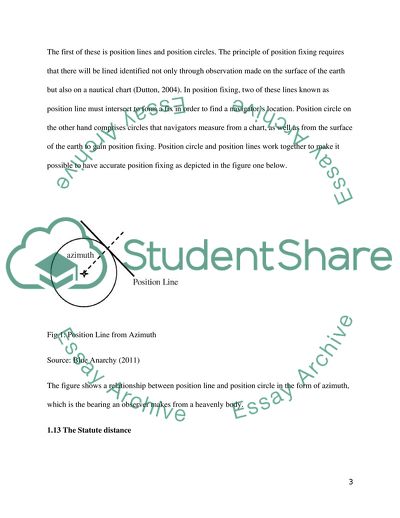
StudentShare
Contact Us
Sign In / Sign Up for FREE
Search
Go to advanced search...
Free

Operational Research and Information Management - Case Study Example

Cite this document
Summary
This paper "Operational Research and Information Management" focuses on the fact that position fixing has been used as an important concept within the American GPS. Position fixing may be explained as a branch of navigation that relies on the use of different visual and electronic methods. …
Download full paper File format: .doc, available for editing
GRAB THE BEST PAPER93.7% of users find it useful
Operational Research and Information Management
Read Text Preview

Extract of sample "Operational Research and Information Management"

School: OPERATIONAL RESEARCH AND INFORMATION MANAGEMENT Lecturer: OPERATIONAL RESEARCH AND INFORMATION MANAGEMENT 1.1 Principle of Position Fixing Position fixing has been used as an important concept within the American Global Positioning System (GPS). As an independent concept, position fixing may be explained as a branch of navigation that relies on the use of different visual and electronic methods to find the position of objects such as ship and aircraft, and a person on the surface of the earth (Dutton, 2004). There are key techniques that make the principle of position fixing by the American GPS functional. 1.11 What is GPS? The Global Positioning System (GPS) can be noted to be one of the few navigation systems in the world, owned by the U.S. Department of Defence. This navigation system functions as a network of 24 satellites which are placed into orbit (Appleyard, Linford and Yarwood, 2008).With this powered 24 satellites placed in orbit, the GPS is able to function in all weather conditions and work in any part of the world on a 24 hour basis. Originally made for military use by the U.S. army, the GPS is now empowered to contain all forms of civilian usage without the need for any procedural subscription or setup fee (Jennet and Tuxedo, 2002). GPS satellites work in a very precise manner by circling the earth twice in a day, going round a specified orbit and transmitting signal information to the earth (Garmin Ltd., 2014). As part of its peculiarities, GPS receivers use triangulation in finding the exact location of a person or object when it receives signal information. 1.12 Position lines and Position Circles The first of these is position lines and position circles. The principle of position fixing requires that there will be lined identified not only through observation made on the surface of the earth but also on a nautical chart (Dutton, 2004). In position fixing, two of these lines known as position line must intersect to form a fix in order to find a navigator’s location. Position circle on the other hand comprises circles that navigators measure from a chart, as well as from the surface of the earth to gain position fixing. Position circle and position lines work together to make it possible to have accurate position fixing as depicted in the figure one below. Fig 1: Position Line from Azimuth Source: Blue Anarchy (2011) The figure shows a relationship between position line and position circle in the form of azimuth, which is the bearing an observer makes from a heavenly body. 1.13 The Statute distance The function of the GPS and other navigation systems is highly dependent on the calculation of distances. For example in the GPS, taking time difference in comparison between the time a signal was received and time signal was transmitted, the GPS undertakes a distance measurement from other satellites to tell user’s position and subsequently display this on the unit’s electronic map (Garmin Ltd, 2014). Meanwhile, in navigation principle, the representation of distance as used in statute distance is different from ordinary nautical distance. For example, a statute mile is 5,280 feet in length but a nautical mile is 6,076.11549…feet in length. By implication, if one wants to have a conversion from statute miles to nautical miles, the person has to use 1.15 as a factor. For example, (5,280 feet X 1.15) = 6,072 feet (4.11549...feet less than 1 nautical mile) (Boat Safe, 2009). 1.14 Celestial Navigation Another of these techniques based on which the principle of position fixing is triggered is celestial navigation. In position fixing, celestial navigation is employed through the use of sights and angular measurements instead of depending on estimated calculations (Grewal, Weill and Angus, 2007). These angular measurements are made between the main celestial bodies, which are the sun, moon, planet and the star and any visible horizon (Agnew and Larson, 2007). Celestial navigation is performed by the use of a sextant. 1.15 Radio Navigation Another of the techniques is radio navigation, which has its own principles for triggering the activity of position fixing. Radio navigation works simply through the triggering of radio frequencies to find various positions on earth (Grewal, Weill and Angus, 2007). The principle of position fixing that works for radio navigation is measurement from and to electric beacons including distance, directions and velocity. The figure below shows typical radio navigation from a VOR in the cockpit. Fig 2 Radio Navigation Function Source: Langley Flying School 1.16 Inmarsat-4 satellite, The Inmarsat-4 Satellite is considered the first effort by Inmarsat to provide the next generation of mobile services using the BGAN platform. There are currently three of these satellites including INMARSAT BGAN, FleetBroadband and SwiftBroadband, which is together give the Inmarsat-4 a high resolution speed through space at a rate of 6,875 mph (Harvey, 2007). One of the key targets of the Inmarsat-4 satellite is to increase existing traffic0bearing capacity. Currently, the range of traffic increase is estimated at 16-fold. There are also expected expansions in high-speed data in space and helping to achieve the global broadband network phenomenon (Appleyard, Linford and Yarwood, 2008). Consequently, all internet and telephony connections in any part of the earth are expected to benefit from this with the exception of the polar areas (Jennet and Tuxedo, 2002). 1.17 Error sources and analysis in GPS There is an internal GPS error analysis system which is purposely in place to examine the sources of any errors in GPS results (Harvey, 2007). The GPS error analysis system also works out the size or extent of error and makes possible corrections. A typical example of this is the correction that GPS makes to the receiver clock errors. Other forms of errors are also coded under the GPS error analysis even apart from the clock error. Some of these include numerical calculations, clock data, multipath signal and atmospheric effects (Appleyard, Linford and Yarwood, 2008). 1.2 Competition between other Global Navigation Satellites Systems and GPS 1.21 Types of GNSS Global Navigation Satellite System (GNSS) come as an assortment of satellite systems that are used for the specific purpose of finding the geographic location of a user’s receiver from any given point in the world (Rouse, 2005). The GNSS currently functioning include the Global Positioning System (GPS) of the United States, Russian Federations Global Orbiting Navigation Satellite System (GLONASS) and Europes Galileo. Made up of three major systems all of all which work by executing a constellation of orbiting satellites function in conjunction with a network ground stations, it is expected that the various systems will compete with each other rather than act as a backup to each other. Even though the functionality of the GLONASS and Galileo may be relatively the same or similar to the GPS, the competition is expected to come in due to the role that the ground stations play, given the fact that the functions of the ground stations add up defined services to the total navigation services that are offered (Dutton, 2004). 1.22 GLONASS GLONASS stands for Global Navigation Satellite System and is currently used as one of the backup navigation systems to the GPS. GLONASS is operated by the Russian Aerospace Defence Force as a space-based satellite navigation system (Harvey, 2007). GLONASS has been considered the best existing alternative to the GPS as it remains the only functional navigation system that has global coverage with precision (Jennet and Tuxedo, 2002). 1.23 GALILEO As GLONASS comes as Russia’s operational navigation system, GALILEO is considered the global navigation satellite system for the whole of Europe. What is unique about the GALILEO is that unlike other navigation systems, this is under direct civilian control (European Space Agency, 2014). There is however no known evidence of global coverage as it serves as an inter-operable with GPS and GLONASS (European Space Agency, 2014). This notwithstanding, the GELILEO is exceptional for high accuracy and guaranteed global positions service. 1.24 Competition Factors among GNSS One of the core areas of differentiation in the output of work of the various GNSS that would cause them to compete with the GPS, rather than serve as a back up to the GPS is the fact that there are different factors that account for the precision of GNSS. The GPS is an instance of the GNSS that has gone through stages of transformation as a means of improving its precision. In eras where selective availability or SA was used to prevent military adversaries from using the positioning data from the GPS, Rouse (2005) observed that the GPS accuracy was highly affected to only a 100-metre range for civilian users. As the SA is no longer in use, accuracy of the GPS has improved further. The Galileo is also known to provide its own range of position accuracy, just as the GLONASS (Agnew and Larson, 2007). Such levels of ambition put up by the various ground stations is therefore the key factor that will result in the issue of competition between the various GNSS instead of serving as a back up to each other. 2.1 Difference between LORAN and GNSS 2.11 LORAN C By the provisions of the 2010 DHS Appropriations Act, the U.S. Coast Guard terminated the tramission of all U.S LORAN-C signals on February 8, 2010 (Navigation Centre, 2010). In its current state however, LORAN C is owned by France, U.K. Germany, Denmark, and Norway. Hitherto the determination by the U.S, LORAN C served as radio navigation service for U.S coastal waters with the system serving 48 continental states and their coastal areas. The system was known for its 0.25 nautical mile absolute accuracy and the provision of navigation services in terms of location and timing services (Navigation Centre, 2010). Today, several agencies continue to debate on the usefulness of LORAN-C as a backup to GPS. 2.12 Difference in Range Known in full as Long Range Navigation, LORAN C functions as a terrestrial radio navigation that identifies the positions of objects and their speed from low frequency radio signals that are transmitted from fixed land-based radio beacons (Dutton, 2004). Because of this, even though position fixing can be given in long range, there are limitations in range when it comes to global distancing, which is an advantage in GNSS, which ranges anywhere on or near the Earth as far as there is an unobstructed line of sight (Everyday Mysteries, 2011). 2.13 Efficiency There is no denying the fact that there are major limitations with the use of the LORAN as compared to the GNSS, making the GNSS a preferred choice for usage over the LORAN. For example, the exchange of LORAN pulses from primary stations to secondary stations has been noted to cause delays through the principle of secondary coding delay (Grewal, Weill and Angus, 2007). Fig 3: LORAN Pulse Source: The Nautical Site (2006) Meanwhile, the GNSS overcomes such issues with efficiency basing on advancements in technologies that have come to produce modernised GPS functionalities such as GPS III satellites and Next Generation Operational Control System (OCX). It is not surprising therefore that GNSS actually came to replace LORAN in terms of usages. 2.14 Mode of Operation The mode of operation between LORAN and GNSS differs, greatly affecting the principle with which the two functions as position fixing. For example, whereas the LORAN uses land radio transmitters to triangulate speed and position, GPS is exclusive to the use of satellites. Based on the use of land radio transmitters, the principle of measuring time difference (TD) between the periods of receiving signal from a pair of radio transmitters to the time of delivering position fixing applies (Grewal, Weill and Angus, 2007). In the diagram below, signals received from radio stations A and B are made constant along each of the hyperbolic curves. Fig 4: Crude Diagram of Time Difference Principle Source: Tyler (2004) Using the CDMA spread-spectrum technique and fixed frequency range of 1.57542 GHz and 1.2276 GHz, most GNSS systems including America’s GPS uses a mode of operation that makes high-rate pseudo random sequence possible and unlimited (Tyler, 2004). 2.2 What is the future of LORAN? 2.21 As a backup to GNSS Into the future, LORAN has been found as an important back up for GPS in the America and other State managed GNSS such as Russia’s GLONASS and Europe’s Galileo. The major argument that has been made for the LORAN as GNSS’s backup is the fact that LORAN uses strong signal, which is resistant to jamming (Dutton, 2004). What is more, unlike individual GNSS systems for the various nations that compete against each other, LORAN comes as an independent and dissimilar system that guarantees availability of navigation signals. Already, there are bodies like Communication, Navigation, Surveillance/ Air Traffic Management/ Implementation Coordination/ Sub-Group(CNS/ATM/IC/SG) that have failed to use GPS in isolation as the sole system for navigation but as a backup with LORAN. 2.22 eLORAN LORAN has also been identified to have future with the enhanced LORAN, also known as eLORAN. As the name implies, this is an advanced system that allows for increased accuracy and usefulness in position fixing and navigation roles as compared to traditional LORAN (Tyler, 2004). The eLORAN has been given an equipped functional platform to perform better than ordinary LORAN as it has advanced receiver design and transmission characteristics similar to what is found with most other GNSS. A major future modification is the inclusion of additional pulses in terms of transmission auxiliary data including Differential GPS corrections (Grewal, Weill and Angus, 2007). Experts have therefore seen a future in eLORAN as a major substitute for GPS and not just as a backup, where GPS is totally absent or is degraded. Reference Agnew, D.C. and Larson, K.M. (2007). "Finding the repeat times of the GPS constellation". GPS Solutions. Vol. 11 No.1: pp. 71–76 Blue Anarchy (2011). Navigating your Dreams by the Stars. [Online] Available at http://www.blueanarchy.org/celestial/ [6th April 2014] Dutton, B. (2004). 15 - Basic Radio Navigation: Duttons Nautical Navigation (15 ed.). Naval Institute Press: New York Everyday Mysteries (2011). What is GPS? Available at http://www.loc.gov/rr/scitech/mysteries/global.html [5th April, 2014] Grewal, M. S., Weill L. R. and Angus A. P. (2007). Global Positioning Systems, Inertial Navigation, and Integration (2nd ed.). John Wiley & Sons Rouse M (2005). GNSS (Global Navigation Satellite System) [Online] Available at http://searchnetworking.techtarget.com/definition/GNSS [6th April, 2014] The Nautical Site (2006). Electronic Position Fixing. [Online] Available at http://thenauticalsite.com/NauticalNotes/ElectSysPosFix/MyElectSysPosFix-Lesson02-LoranC.htm [5th April, 2014] Tyler K. (2004). “Crude diagram of time-difference principle. Journal of Nautical Studies. Vol. 5 No, 2, pp. 42-55 Navigation Centre (2010). LORAN C General Information. [Online] Available at http://www.navcen.uscg.gov/?pageName=loranMain [11th April 2014] Garmin Ltd. (2014). What is GPD? [Online] Available from http://www8.garmin.com/aboutGPS/ [April 9, 2014] Boat Safe (2009). Statute Miles vs. Nautical Miles. [Online] Available at http://www.boatsafe.com/nauticalknowhow/miles.htm [April 10, 2014] European Space Agency (2014). What is GALILEO? [Online] Available at http://www.esa.int/Our_Activities/Navigation/The_future_-_Galileo/What_is_Galileo [April 10, 2014] Appleyard, S.F., Linford, R.S. and Yarwood, P.J. (2008). Marine Electronic Navigation (Revised Edition). Routledge & Kegan Paul: London Jennet C. And Tuxedo P. (2002). A Wall Street Tycoon and the Secret Palace of Science That Changed the Course of World War II. Simon & Schuster: New York Harvey, B. (2007). "Military programs". The Rebirth of the Russian Space Program (1st ed.). Springer: Germany Read More
Tags
Cite this document
  • APA
  • MLA
  • CHICAGO
(Operational Research and Information Management Case Study, n.d.)
Operational Research and Information Management Case Study. Retrieved from https://studentshare.org/information-technology/1818951-operational-research-and-information-management
(Operational Research and Information Management Case Study)
Operational Research and Information Management Case Study. https://studentshare.org/information-technology/1818951-operational-research-and-information-management.
“Operational Research and Information Management Case Study”. https://studentshare.org/information-technology/1818951-operational-research-and-information-management.
  • Cited: 0 times

CHECK THESE SAMPLES OF Operational Research and Information Management

Operation Mangement (forcasting)

Operation management also considers the development, acquisition and utilization of the available resources that most firms need to deliver to their clients such as services and goods.... … Operation management has played a big role in the current business industry and as a result, it is important to provide people with more information about it.... Operation management mainly deals with design and the management of services, processes, products and the supply chains....
16 Pages (4000 words) Research Paper

Operations and IT Management

ILM offers a Records and information management (RIM) for 30 years already and had its roots from information management using microfilm, negatives, photographs, audio or video recordings and other assets including video lifecycle management (Longley and Shain, 1985).... t is in this context that Information Lifecycle Management (ILM), a practice of employing policies for effective information management through its ‘useful life', is introduced to resolve potential and escalating conflicts between operation and information managers of a company or firm (Robbins, 2006)....
2 Pages (500 words) Research Paper

Operation Management

Although, there is core information about the hotel I need some more to provide quality research and implement the tools.... Operation management Your Name Institution's Name Executive summary Hotel is complex business unit that belongs to the service industry.... This makes operation management very important in this business and ability to set each process so that all hotel is functioning as one mechanism is considered as the mix of science and art....
10 Pages (2500 words) Research Paper

Operation Management

Operation management BY YOU YOUR SCHOOL INFO HERE DATE HERE Executive Summary The hotel in the case study can take advantage of many benchmarking activities related to improving employee relations, launching eco-friendly technology initiatives and programmes and also providing training to employees regarding customer culture and attitude.... Operation management 1.... The hotel's three kitchens will require more demands, especially in relation to quality and management, as it is designed to cater and service walk-in patrons from the external environment and guests as well....
10 Pages (2500 words) Research Paper

Value and Drawbacks of Activity Based Management

Activity based management uses the data and information on all the operational activities in making relevant and result oriented decisions.... VALUE AND DRAWBACKS OF ACTIVITY-BASED management Name: Institution: Introduction Activity based management refers to a management approach that applies activity based costing designed for decision-making and development of organizational strategies.... Activity based management is an approach that uses the available information in a given organization to make more effective and efficient decisions....
5 Pages (1250 words) Research Paper

Dell Computer Corporation

Similarly, apart from the strong brand value and robust market position, there are flaws in some product segments along with feeble research and development outputs.... Full Paper Title Name University Executive Summary The paper will discuss management information systems fundamental concepts in alignment with Dell Incorporated.... In addition, Dell inventory management system will also be discussed along with its importance.... management Information Systems It is fundamental that information systems can be categorized as transaction processing systems (TPS), management information systems (MIS) and Expert systems (ES)....
3 Pages (750 words) Research Paper

The Benefits of Service Outsourcing

Business Name Name of institution Date Essentially most of the companies that provide services rely on the customer's natural promptness to pay for the services either after a fortnight or on a monthly basis depending on the policies guiding service contracts.... hellip; The electrical and contracting company offers both electricity and contracting services to clients....
5 Pages (1250 words) Research Paper

Operations management at Starbucks

Operations management at Starbucks Name Class Professor About Starbucks Corporation Starbucks Corporation is a coffee shop company based in America.... With the use of a high innovative management and market research, the company has dominated the service of hot and cold beverages....
11 Pages (2750 words) Research Paper
sponsored ads
We use cookies to create the best experience for you. Keep on browsing if you are OK with that, or find out how to manage cookies.
Contact Us