StudentShare
Contact Us
Sign In / Sign Up for FREE
Search
Go to advanced search...
Free

The Holographic Global Positioning System Interface - Assignment Example

Cite this document
Summary
This paper "The Holographic Global Positioning System  Interface" focuses on the intelligent location of the vehicle and navigation information that will enable the users to avoid the freeway. It is a crucial tool for surveying and map-making and has become one of the most important global utility…
Download full paper File format: .doc, available for editing
GRAB THE BEST PAPER98.2% of users find it useful
The Holographic Global Positioning System Interface
Read Text Preview

Extract of sample "The Holographic Global Positioning System Interface"

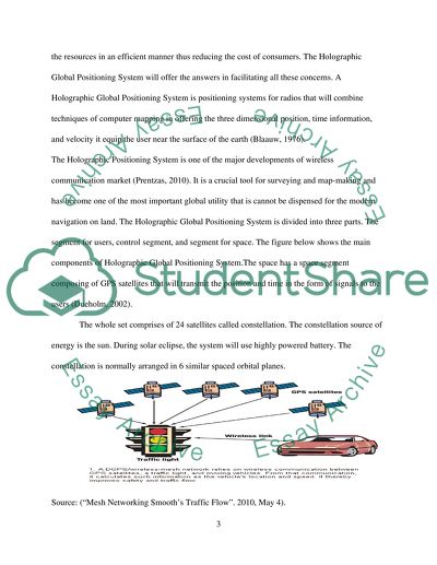
holographic global positioning system al Affiliation) Key words: GPS, Interface Device Introduction The Holographic Positioning System is one of the major developments of wireless communication market (Prentzas, 2010). It is a crucial tool for surveying and map-making and has become one of the most important global utility that is cannot be dispensed for the modern navigation on land. The Holographic Global Positioning System is divided into three parts. The segment for users, control segment, and segment for space. The Holographic Global Positioning System will offer intelligent location of the vehicle and navigation information that will enable the users avoid freeway that is congested. Additionally, the system will find more appropriate routes to the destination of users, saving them a lot of money in the air pollution and in gasoline. The cars will therefore be safer in any condition of the weather. Business having larger outlet numbers like the utilities will manage the resources in an efficient manner thus reducing the cost of consumers. The Holographic Global Positioning System will offer the answers in facilitating all these concerns. 2. Critical Exploration The Holographic Global Positioning System will offer intelligent location of the vehicle and navigation information that will enable the users avoid freeway that is congested. Additionally, the system will find more appropriate routes to the destination of users, saving them a lot of money in the air pollution and in gasoline (Rabbany, 2002). The cars will therefore be safer in any condition of the weather. Business having larger outlet numbers like the utilities will manage the resources in an efficient manner thus reducing the cost of consumers. The Holographic Global Positioning System will offer the answers in facilitating all these concerns. A Holographic Global Positioning System is positioning systems for radios that will combine techniques of computer mapping in offering the three dimensional position, time information, and velocity it equip the user near the surface of the earth (Blaauw, 1976). The Holographic Positioning System is one of the major developments of wireless communication market (Prentzas, 2010). It is a crucial tool for surveying and map-making and has become one of the most important global utility that is cannot be dispensed for the modern navigation on land. The Holographic Global Positioning System is divided into three parts. The segment for users, control segment, and segment for space. The figure below shows the main components of Holographic Global Positioning System.The space has a space segment composing of GPS satellites that will transmit the position and time in the form of signals to the users (Dueholm, 2002). The whole set comprises of 24 satellites called constellation. The constellation source of energy is the sun. During solar eclipse, the system will use highly powered battery. The constellation is normally arranged in 6 similar spaced orbital planes. Source: (“Mesh Networking Smooth’s Traffic Flow”. 2010, May 4). Each and every plane comprises of the 4 satellites and is inclined at around 50 degrees from the equator. The configuration has a world-wide coverage because the four satellites are found from any location and position on the surface of the earth at all times. The control segment comprises of the facilities that are ground based that are used in monitoring and controlling the satellites. The satellites can never be observed by the user (Dueholm, 2002). The control segment consists of the uplink stations and tracking station around the continent and the master control station located at a strategic position. The monitoring and controlling stations measures the signals from the satellites which are found into the orbital models for every satellite. The models tend to compute the ephemeris and clock corrections for every satellite (Johnson, 2006). The master controlling stations will update the clock data and ephemeris through the uplink station s to satellites, which then transmits the subsets of the ephemeris to the Global Positioning Systems receivers over the signals of the radio. Therefore, the Holographic Global Positioning System will offer intelligent location of the vehicle and navigation information that will enable the users avoid freeway that is congested. Additionally, the system will find more appropriate routes to the destination of users, saving them a lot of money in the air pollution and in gasoline (Rabbany, 2002). 3. User Needs Analysis. The Holographic Global Positioning System will have two separate segments; for receivers and for users. The Holographic Global Positioning System receivers are the specialized radio receivers that are designed to be listening to the signals from radio being transmitted from satellites. The process will need 4 satellites for computing the four dimensions. The X, Y, Z, and time. Bearing in mind the mentioned abilities, the Holographic Global Positioning System will have three main functions; navigation, positioning, and frequency and time dissemination. The receivers for Holographic Global Positioning System will come in various sizes, price ranges, and shapes. Some of them comprises of the palm tops and integrated mobile phones. The user needs analysis will entail the application proper understanding of Holographic Global Positioning System application. The Holographic Global Positioning System will be helpful in car navigation system. Before a trip is commenced, the car driver will need to feed the Holographic Global Positioning System receiver with his destination, The Holographic Global Positioning System will help the driver find its way quickly and easily. When the driver will be driving on strange roads or when caught in heavy traffic, the most fastest and convenient way of locating his destination will be through the help of Holographic Global Positioning System. Through the satellite, the Holographic Global Positioning System of the car will be able to help the driver locate possible routes to his destination. Irrespective of the functional tendency, the Holographic Global Positioning System of the car will give the user additional information which might be of interest to the user. The information available on Holographic Global Positioning System to the users will include the fastest and shortest route to one’s destination, the fuel needed, and the expected time of travel. 3.1 Persona for HGPS 3.2 Scenario The exact location for the cars can be found almost anywhere using the device. This is through using the Global Positioning System (GPS). The system consists of the 24 satellites that work independently in creating the exact earth’s view. Using technologies that are advanced, the satellites tend to compare a single location to a number of them and then come up with a location with a greater accuracy degree. One mechanism of taking advantage of the technology is getting a GPS receiver a portable device. The device helps in finding the longitude and the latitude and enhancing the correct location of the car using the receivers based on the location knowledge. In other terms, knowing where one should be, enable one to figure where someone is. Therefore, the most fun use of the device is cars. The GPS receivers will be installed in vehicles which will help one in finding out the position and location of a person on a road. The businesses use the system to keep track of vehicles therefore, helping them increase their productivity and fuel cost reduction. When the information is combined with accurate maps, the users will have a perfect way of navigating. Soon the boats and cars will have the receivers of the devices built in, together with maps that are computerized and the driving directions. One will be able to employ the satellite service in telling a person the quickest routes to his destination. 3.3 Task Analysis Installing the Holographic Global Positioning System will help the user enjoy their journey since they will be saving time. Additionally, they will be prevented from getting lost on their way to their destinations. The most practical application for this system is seen in some of the rental cars. Some companies that deal with renting out cars have embraced the idea by installing the Holographic Global Positioning System on their cars in monitoring the speed, location, and mileage of their cars. The companies have debited heavy penalties on client who found speeding or travelling out of the areas specified on the leasing agreement. The monitoring process has been challenged since the practice of monitoring has never been put forth to the clients. Here it is presumed that the leasing company has interfered with the privacy of the client (Pechenizkiy, 2013). Therefore, some of the vehicles sold to buyers having poor credit history are more likely to be installed with the transmitting units of the GPS in monitoring the car’s whereabouts and disabling in case loan default are prone to happen. Therefore, the Holographic Global Positioning System of the car will combine the technology from GPS with a communication system in tracking the progress of the driver. 3.4 Environmental Analysis When the driver will be driving on strange roads or when caught in heavy traffic, the most fastest and convenient way of locating his destination will be through the help of Holographic Global Positioning System. Through the satellite, the Holographic Global Positioning System of the car will be able to help the driver locate possible routes to his destination. Irrespective of the functional tendency, the Holographic Global Positioning System of the car will give the user additional information which might be of interest to the user. The information available on the Holographic Global Positioning System to the users will include the fastest and shortest route to one’s destination, the fuel needed, and the expected time of travel. Installing the Holographic Global Positioning System will help the user to enjoy their journey since they will be saving time. Additionally, they will be prevented from getting lost on their way to their destinations. The most practical application of this system is seen in some of the rental cars. Some companies that deal with renting out cars have embraced the idea of installing the Holographic Global Positioning System on their cars in monitoring the speed, location, and mileage of their cars. The companies have debited heavy penalties on clients who found speeding or travelling out of the areas specified in the leasing agreement. 4. Preliminary Design The car navigation system will combine the Holographic Global Positioning System with the communication system from the computer in tracking the progress of the driver on the digital map. The system will offer services such as fastest route, shortest route on the motorways and roadways which are always congested. The application is normally referred to the optimal car routing and is normally applied in the GPS commercial application. The Holographic Global Positioning System for the car will combine the telecommunication and telematics in carrying out the survey and positioning. Before, designing the GPS, the preliminary design is done for the satellite. While in continuous motion, each and every satellite found in the constellation of GPS continuously broadcast the signals of the radio in every direction. The satellite contains the data about the exact time, orbit, and the equipment status. Another preliminary is the receiver, the receivers have a computer and an antenna mounted on the car’s dashboard. Additionally, the receiver computer has digital road map found in memory that has the list of roads found in the county. The user will only be required to key in the destination details on the screen of computer and waits for the computer details to be given out. The clocks for the satellites and those of computers are synchronized. Because the earth’s center of gravity influences the degree at which the clock changes, the clock do not undergo synchronization relative to each other but as their velocity’s function relative to the coordinate system center. The satellite packets contain the time stamp forming a packets part. When the packets are received, the clock receiver reads the second time. The transmission and the wavelength of the signal will be measured. The clock synchronization will then find out the distance existing between the car and satellite (Johnson, 2006). The use of a single positioning system can be envisaged for tracking the vehicles with Holographic Global Positioning technique while supportive technique of satellite is used in locating vehicles on the surface of the objects. The global positioning systems have less technical requirement for instance updating might be discontinuous and the frequency. The appealing 3D tracking system is developed at the research intervals. The principle works using a similar technique like that of Radio Frequency ID reading system and is capable of tracking 3D positions to an extent of tracking 128 passive tags in a simultaneous manner. The RFID technique is used to draw tablets and the capabilities is elaborate as shown in the drawing tablets with devices having wireless interaction. The sense board has the same function with intrigue RFID grid receivers used in determining the 2D location of RFID tag. Practically, the system relies on the tracking table, and has possibilities of extending this to sensing grids that are flexible. 5. Detailed Design 5.1 Decisions Relating to User Needs Analysis The Holographic Global Positioning System will have two separate segments; for receivers and for users. The Holographic Global Positioning System receivers are the specialized radio receivers that are designed to be listening to the signals from radio being transmitted from satellites. The process will need 4 satellites for computing the four dimensions. The X, Y, Z, and time. Bearing in mind the mentioned abilities, the Holographic Global Positioning System will have three main functions; navigation, positioning, and frequency and time dissemination. The receivers for Holographic Global Positioning System will come in various sizes, price ranges, and shapes. Some of them comprises of the palm tops and integrated mobile phones. The user needs analysis will entail the application proper understanding of Holographic Global Positioning 5.2 Decision Relating to Usability Assuming a system has “n” coordinates, with a minimum “n” line, they need to intersect so that the point’s coordinates can be specified. This is the idea behind the design of the system. The GPS system origin comes from the middle of the earth. Each of the satellite will specify a line. Therefore, minimum of 3 satellites are needed in determining the coordinates of the car. The fourth satellite is required in specifying the time. The Holographic Global Positioning System will have accurate clock using the atomic vibration as a basic unit for time. Assuming the receiver clocks are taken into consideration, the scenario will turn out to be very different. The receiver employs cheap quartz clocks, since accurate measurement of time are crucial factors of the GPS, a slight error of the clock will result to a massive positioning error. The higher the seen receiver satellites the higher the measurement accuracy and the fewer error positions will be obtained. The accuracy of the GPS will be +- 10 meters. 5.3 Decision Relating to Cognitive Issues The relativity of the GPS will be important for the clock to work in a systematic manner. The two theories will surely play in determining the accuracy of the system; the general relativity and specific relativity. The General Relativity, assumes the moving object’s clock depends on the position of the click and the field’s velocity of nearby weights and masses. Therefore, the clock is nearer the massive object, the clock will tick slowly and vice-versa. The special relativity shows that the moving object’s clock ticks at a slower pace than the stationery objects. Therefore, assuming that the object is moving at a velocity v, then the clock’s tick rate will be given as C is taken to be the speed of light, f0 is the rate of ticking clock in a stationery position. Assuming that the two objects are moving, v will be the relative velocity between them. Therefore, the above equation is referred to as the time dilation. 6. Implementation Modeling the communication system’s performance, the system dimensioning and designing the system are implemented. Implementing the system involves quantifying the system gotten from the options of designs whereas in the dimensioning of the system the size of the planned utilization is determined. The positive feedback gotten from the performance modeling study to outshine the cost of the system. After defining the evaluation method, the solution method and performance metrics is defined. The methods of implementation can be the real system measurement and Discreet Event Simulation. The real system measurement involves using the complex instruments. In Discreet Event Simulation, a simple system’s model is implemented using certain software. The interest performance is measured. Additionally, the mathematical analysis involves modeling the system mathematically and then conducting the numerical analysis (Blaauw, 1976). 7. Evaluation 7.1 Cognitive Walkthrough The road traffic measurements cannot be made when the parameters to be evaluated is not known. First, it is imperative to define the performance metrics and try to determine the evaluation that need to be carried out. Evaluating the route segmentation, one need to know the complete route. The evaluation of the system can be done by defining the performance measures. The base for the performance measures is acceptable travel time and the travel time. From the two quantities all the other measures of performance can be evaluated. The travel time will entail a consensus between the non-technical and technical teas. The proper evaluation will be done based on the stochastic analysis. From the travel time and other performance measures, drivers would be able to know the optimal route to their respective destinations. For further research, I suggest that traffic management centers could use GPS technology for scheduling purposes as well. In the event where there is heavy traffic on a given route segment, the travel time increases. In addition to informing incoming areas to the route segment (usually in the form of electronic boards) about this traffic situation, they could also provide them other possibilities of reaching their respective destinations in relatively a little amount of time. In his way, fuel consumption, air pollution, etc., can be reduced. 7.2 Heuristic Evaluation Therefore, The Holographic Global Positioning System will offer intelligent location of the vehicle and navigation information that will enable the users avoid freeway that is congested. Additionally, the system will find more appropriate routes to the destination of users, saving them a lot of money in the air pollution and in gasoline. The cars will therefore be safer in any condition of the weather. Business having larger outlet numbers like the utilities will manage the resources in an efficient manner thus reducing the cost of consumers. The Holographic Global Positioning System will offer the answers in facilitating all these concerns. 8. Coherence The exact location for the cars can be found almost anywhere using the device. This is through using the Global Positioning System (GPS). The system consists of the 24 satellites that work independently in creating the exact earth’s view. Using technologies that are advanced, the satellites tend to compare a single location to a number of them and then come up with a location with a greater accuracy degree. The Holographic Global Positioning System will help the driver find its way quickly and easily. When the driver will be driving on strange roads or when caught in heavy traffic, the most fastest and convenient way of locating his destination will be through the help of the Holographic Global Positioning System. Through the satellite, the Holographic Global Positioning System of the car will be able to help the driver locate possible routes to his destination. Irrespective of the functional tendency, the Holographic Global Positioning System of the car will give the user additional information which might be of interest to the user. The relativity of the GPS will be important for the clock to work in a systematic manner. The two theories will surely play in determining the accuracy of the system; the general relativity and specific relativity. The General Relativity, assumes the moving object’s clock depends on the position of the click and the field’s velocity of nearby weights and masses. Reference Blaauw, G. A. 1976. Digital system implementation. Englewood Cliffs, N.J.: Prentice-Hall. Dueholm, K. S. 2002. GPS 2. udgave, 1. oplag ed.. Kbh.: Ingeniøren-Bøger. Johnson, R. L. 2006. Satellites. Minneapolis, MN: Lerner Publications. Molina, H., Ullman, J. D., & Widom, J. 2000. Database system implementation. Upper Saddle River, N.J.: Prentice Hall. Pechenizkiy, M. 2013. New trends in databases and information systems. Berlin: Springer. Prentzas, G. S. 2010. GPS. Ann Arbor, Mich.: Cherry Lake Pub. Rabbany, A. 2002. Introduction to GPS the Global Positioning System. Boston, MA: Artech House. Read More
Cite this document
  • APA
  • MLA
  • CHICAGO
(“HGPS Interface Assignment Example | Topics and Well Written Essays - 2250 words”, n.d.)
Retrieved from https://studentshare.org/information-technology/1637286-hgps-interface
(HGPS Interface Assignment Example | Topics and Well Written Essays - 2250 Words)
https://studentshare.org/information-technology/1637286-hgps-interface.
“HGPS Interface Assignment Example | Topics and Well Written Essays - 2250 Words”, n.d. https://studentshare.org/information-technology/1637286-hgps-interface.
  • Cited: 0 times

CHECK THESE SAMPLES OF The Holographic Global Positioning System Interface

Holographic Storage: The Future in Massive Storage

This essay covers the scope of holographic storage technology by describing its operation and applications.... In conclusion, the author opines that holographic storage technology would be implemented to ease storage of large amounts of information  …  Removable computer data storage devices have revolutionalized sharing of information across the globe.... holographic technology has already been used in facilities such as credit cards where holographic images are used although it has not been embraced on a wider scale as an alternative form of storage (Owen, 2000)....
16 Pages (4000 words) Essay

Importance of Positioning in Marketing

Positioning is much like a ranking system.... Positioning is much like a ranking system.... (Pinson, Linda;… positioning establishes the desired perception of the product, within the target market, relative to the competition.... A well-planned and executed positioning positively differentiates the product from the competition.... For maximum effectiveness, all positioning What does postioning mean in marketing?...
2 Pages (500 words) Essay

Global Positioning Satellite System (GPS) and Phones

ldquo;global positioning Systems (GPS) reveal a person's location.... The police can identify the location of the person who is being kidnapped with the help of the GPS system easily.... “Government officials and communications experts are assessing the public safety and security implications of a newly posted online article that provides directions for making cheap devices that can jam global PositioningSystem (GPS) signals....
6 Pages (1500 words) Essay

Holographic Design Building

This emergent approach is called the holographic design of an organization.... The principles of the holographic design (Morgan, 2006) are used hereunder to conceptualize the organization from a holographic perspective:The organization chosen has been named ‘X' and the principles are as under:Build the “whole” into all the “parts.... ??The first principle of the holographic design represents the incorporation of the vision and values of the whole organization in to the individual parts....
2 Pages (500 words) Essay

Development and new trend of holography

A holographic image can be viewed shinning a laser via a hologram and projecting the reflection onto a display or by looking into a lit-up holographic print.... A holographic film physical medium is quite photosensitive that includes a fine grains structure....
8 Pages (2000 words) Essay

Advanced Systems Design Project

The device will have a paralyzed robot that will be in a position to reach a certain point via a lee way that can be determined before the implementation of the system.... To carry out the task the operators will be in a position to carry out the perception of the system that will be used in determining the error of the paper....
13 Pages (3250 words) Essay

Global Positioning System

hellip; The present research has identified that the technology of the global positioning system is making huge changes in the society that have never been before seen.... The Department of Defense ultimately created a Joint Program Office (JPO), which strengthened the developments of the global positioning system (GPS).... The cost of the receivers is dropping while at the same time the precision of the system is enhancing.... NAVSTAR (Navigation system for Timing and Ranging) is the actual name of GPS but is generally referred to as GPS....
7 Pages (1750 words) Research Paper

Global Positioning System

"global positioning system" paper focuses on G.... The need for such a system arose when mankind was confronted with difficult and unforeseen situations in natural disasters like earthquakes and tsunamis.... A 4D geographical information system is another step ahead in the coming days which would allow further advancements.... The mapping system adds value to the entire concept and it serves as the identification mark, for example in sensitive areas, dots can be put in form of maps, and can be highlighted for monitoring and surveillance....
6 Pages (1500 words) Coursework
sponsored ads
We use cookies to create the best experience for you. Keep on browsing if you are OK with that, or find out how to manage cookies.
Contact Us