StudentShare
Contact Us
Sign In / Sign Up for FREE
Search
Go to advanced search...
Free

The Importance of Using GIS Systems - Term Paper Example

Cite this document
Summary
The work "The Importance of Using GIS Systems" describes the main opportunities of using special guides, GIS systems in order to know the location, distance, transport. The aim of this work to show the principles, advantages, and importance of GIS Systems in everyday life. …
Download full paper File format: .doc, available for editing
GRAB THE BEST PAPER96% of users find it useful
The Importance of Using GIS Systems
Read Text Preview

Extract of sample "The Importance of Using GIS Systems"

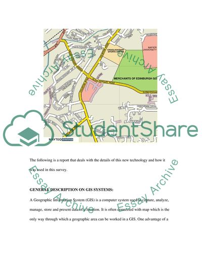
MAPPING & GIS 2 INTRODUCTION: Geography plays an important role in one’s everyday life. If one wants to leave his house and go to the market and get some vegetables, he must know where the market is and how to get back home. A lot of geography is involved in that simple routine. This is just a trivial example that shows the role of this subject in everyday life. So, the importance of geography on a global level is only too evident. Geographical Information System or GIS, as it is usually called, is a recent technological development that integrates hardware, software and data to capture, manage, analyze, interpret and present the geography referenced information in the form of maps, charts, globes and reports in a manner that is easy to understand. This technology can be used in many surveys and projects. One such survey was undertaken to determine if an additional bus service is required on Colinton Road passing through Merchiston Campus of Napier University, Edinburg, United Kingdom. This survey was conducted with over 100 students studying in different disciplines of study at Merchiston Campus of Napier University. Geographical Information System (GIS) tool-Auto CAD (Computer Aided Design) software application for 2D and 3D design and drafting had also been used to map the information collected using the results of the survey. The following is the Napier University Street map obtained from http://www.streetmap.co.uk/newmap. The following is a report that deals with the details of this new technology and how it was used in this survey. GENERAL DESCRIPTION ON GIS SYSTEMS: A Geographic Information System (GIS) is a computer system used to capture, analyze, manage, store and present data of a location. It is often connected with map which is the only way through which a geographic area can be worked in a GIS. One advantage of a GIS system is that it is capable of dealing with many problem-solving than restricting itself to simple mapping program, adding or deleting data. (Breunig. M, 2001, p.20) A GIS system can be viewed in three different ways: THE DATABASE VIEW. (Breunig. M, 2001, p.20) THE MAP VIEW. (Breunig. M, 2001, p.20) THE MODEL VIEW. (Breunig. M, 2001, p.20) The most important use of a GIS connection is that it can accentuate on the objects being mapped. A computer-aided mapping system can be used to represent a road just as a line, but a GIS will recognize the road with minute details like if the road is a boundary between two lands, etc. (Breunig. M, 2001, p.20) There are different kinds of GIS systems which are classified based on their features and uses. The ability of a GIS is its power to relate different information and detect the relationships with the provided information. (Breunig. M, 2001, p.20) PRINCIPLES: Digital mapping is mainly used for storing and displaying a map data in a digital form. The digital mapping makes use of certain methods to obtain data. Some of the common methods used in digital mapping are the GPS software, Aerial Photogrammetry, etc. THE GPS SOFTWARE: Earlier Thomas Guide used to be the acme for car navigation, but now the portable navigation systems like the GPS facility and digital mapping has created a new revolution of navigation. This basic advantage of this system gives clear driving directions from the starting point to the destination of a person, a detailed map; the important land marks in-between the drive and various other details. The recent GPS systems have bought in many recent technologies like: The address entry by voice. Text-to-speed functionality. An integrated Bluetooth. Quick one-click access to the preferred destinations. Historical traffic data and advance lane guidance and many more. This makes the GPS system more sophisticated and highly reliable to use. It is very useful especially for people who are new to the place. THE AERIAL PHOTOGRAMMETRY: The photgrammetry is a technique used to measure 2D and 3D objects from photo-grammes. The most important feature is that the objects can be measured without touching it, this is the reason some people call it remote sensing instead of photogrammetry. The term remote sensing has come more recently widened though initially it was confined with working to aerial photographs and satellite images. But now, it also includes photogrammetry though it is associated with image interpretation. (n.d. Introduction to Photogrammetry) REASONS FOR SELECTING THE AREA IN QUESTION: The objective of the survey was to find out whether an additional bus service was required on Colinton Road which passes through Merchiston campus of Napier University in Edinburgh, in the United Kingdom. The Geographical Information System was made use in the analysis to ascertain bus services that were being provided by the Lothian Bus Company, the bus no.45 in particular, as it was the bus plying through the area at half hour intervals. The bus service however does not ply to the areas that are located at a greater distance from the campus. The survey intended to reveal whether the students were convenient with the present bus service or whether they required additional bus service. The survey revealed that most of the students came from the post code areas marked E11, which was the closest to the campus, at the rate were walking and bicycle riding was preferred. The other area E10 was slightly farther away from E11. The survey showed that among the 100 students, 45 made use of the bus facility each day. This is the reason why I picked this particular location, majority of the students hailed from these areas with the overall majority of majority of 45 opting for the bus service. The effectiveness of GIS and the subject matter of the survey will be more substantial only when the majority is taken into account. The GIS covers a larger area than the GPS and also provides more details and serves a larger purpose than a mere tracking device. This system is only put to best use either on a large demographic or amongst a majority of people. Besides that, a certain majority is expected for work to be qualified as substantial and to be taken into account when the results of a survey are presented. Moreover it only makes logical sense to go about the survey in this manner. Details of how data included in the file have been obtained: As mentioned earlier, the survey was conducted to determine if an additional bus service was required on the Colinton Road passing through Merchiston Campus of Napier University, Edinburg, United Kingdom. It was found that only one bus (Bus no 45) plies once in half an hour on Colinton Road and connects the university to the other parts of the city, from Monday to Friday. To conduct this survey, a total of 100 students were considered the participants of this survey. A questionnaire was distributed to all the participants and based on their answers, a decision was made. The questionnaire mainly focused on the following: The number of people living near the campus The time taken for them to reach their destination A personal opinion of the individual on the requirement of an additional bus service and the reasons for the same. Based on these and many other questions, people decided against providing an additional bus service on Colinton Road. The main reason was that out of 100, only 45% of people used the bus service, out of which 41% alight at the stop near campus, while rest 59% prefer to use the bus which makes them get down at the bus stop at some distance from the campus. It was also found that a total of 55% of people live in the EH11 and EH10 areas (post codes). Therefore based on the response of this maximum number of people a decision was arrived at. Therefore, a general agreement was in favor of continuation of status quo. As people were satisfied with the prevailing bus facility despite it not reaching students stationed farther off from the campus, it was therefore agreed that an additional bus service would not come of much benefit to the students or the company providing the service- Lothian Bus Company. PROBLEMS ENCOUNTERED There were many problems encountered when creating the GIS. Most of these problems are common to all technology that makes extensive use of satellite services. Atmospheric problem of refractive index is common obstacle to accuracy. Light travels its best in the absence of any medium such as air and water. The presence of the medium affects accuracy to some degree. Other atmospheric effects like ionospheric and tropospheric effects, the refraction and reflective index of light affects the accuracy of GIS. There were errors in the system initially which had to be rectified, however they are of recurrent nature. We had to encounter problems of power failure and interruptions, and there were also minor problems with the on board microprocessor. There were also times when the software refused to co-operate or function effectively. These were however overcome in due course of time. When discussing errors and problems encountered while creating the GIS, the problems faced on preparing the data for inception is also stated. Data collection was not an easy task though the key components were collected from reliable sources. More amount of time was spent on this part of the project, as the sources were not very easily accessible. Data encoding and exchange also added to the list of problems. The data programmed in the GIS was not comprehensive enough and it therefore had to be rewritten in a comprehensive manner. Minor problems were faced when it came to loading the information in the software also, which did not consume much time. Errors and problems are inherent in any kind of job especially when it is of technical nature. Problems connected with software functioning, encoding and decoding of data consumed a considerable amount of time, but were overcome in the end. The aspects of accuracy teamed with a comprehensive and simple usage was the target which was finally achieved. GENERAL USES OF THE GIS Geographical Information System or GIS as is called has a lot of uses. It is applicable for usage in almost every field. The general uses of the GIS are mentioned below. GIS technology helps us to represent data in the form of maps, charts, globes and so on. This enables better comprehensibility. GIS comes in handy for by planners, engineers, cartographers, construction companies, surveyors, architects, marketing analysts and so on. It provides industries like the forestry, Homeland Security etc., tools for better decision making and analysis of issues. GIS is also used for analyzing data on population distribution, traffic movements, land availability, real estate prices, environmental hazards, soil types, flood zones, disaster zones etc. The following are other industries that use the GIS technology: (Geography Matters, 2008) Education Telecommunication Conservation Banking and Insurance Natural Resources and so on Thus GIS is useful for many such purposes. For instance, the uses of GIS with respect to transportation industry are mentioned below for better understanding. (Geography Matters, 2008) INSTRUCTIONS TO USE THE GIS SYSTEM The GIS system was designed to be used in the survey which was conducted to ascertain whether an additional bus service was required on the Colinton Road which passes through Merchiston Campus of Napier University, Edinburg, United Kingdom. There were two areas that was the main focus of this particular GIS, namely, the areas with the postal code E10 and E11, where majority of the students came from. Given below are the general instructions for using this GIS system. The screen layout is such that it contains an overview of the map, the toolbar and also the main map. The right side of the screen contains the various layers, which the user can choose to see. A specific map display can also be viewed with a combination of layers, however only one layer can be active at a time. An option called “Refresh map” is provided to update the map display. There is a toolbar equipped with various tools provided to help the user manipulate the map to his wishes. Tools like zoom in, zoom out, the pan tool (for moving the map around), the identity tool (for displaying information of a specific feature), the query tool, the find tool etc. to view the map from various angles. PRACTICAL USES OF THE GIS: The GIS has many practical uses in various fields like tourism, construction etc. It is also immensely being used in the transportation industry and therefore the use is elaborated below. USES IN THE TRANSPORTATION INDUSTRY: GIS is a system that is mainly used to display and analyze the information geographically. The field that can make use of it the most is the transportation field. In the transportation industry, analyzing the different geographic location will help to make better decisions. GIS helps in fulfilling three transportation needs like: The management of the infrastructure. (Geography Matters, 2008) The fleet and provisions management. (Geography Matters, 2008) The transportation management. (Geography Matters, 2008) The transportation professionals make use of the GIS system to incorporate mapping analysis for the network planning and analyzing, tracking and routing of the vehicles, planning and analyzing the routes of different vehicles, detailed tracking, the routes taken by a particular vehicle, the stops of the vehicle and much more. (Geography Matters, 2008) CONCLUSION The advent of the Geographical Information System has made things much easier for man. GIS has been a blessing in disguise especially for conducting surveys and researches where accuracy of data is very important. In that case the GIS technology is very useful. The uses of GIS and its application in many areas are evident from the above. It is with the help of GIS and Auto CAD software that the maps have been designed in the survey conducted to determine whether an additional bus service is needed on Colinton Road passing through Merchiston Campus of Napier University, Edinburg, United Kingdom. The GIS that was done by us also has considerable advantages and other uses as mentioned above. References Breunig. M, 2001, On the Way to Component-based 3D/4D Geoinformation Systems: With 106 Figures and 2 Tables (Electronic Version) Springer, p.20 from http://books.google.com/books?id=VLFIgI2tJqAC&pg=PA20&dq=gis+types n.d. Introduction to Photogrammetry (Electronic Version) from, http://www.univie.ac.at/Luftbildarchiv/wgv/intro.htm ESRI, 2008, Geography Matters (Electronic Version): from, http://www.gis.com/whatisgis/geographymatters.pdf Read More
Cite this document
  • APA
  • MLA
  • CHICAGO
(The Importance of Using GIS Systems Term Paper Example | Topics and Well Written Essays - 2250 words, n.d.)
The Importance of Using GIS Systems Term Paper Example | Topics and Well Written Essays - 2250 words. Retrieved from https://studentshare.org/technology/1719329-mapping-gis-2
(The Importance of Using GIS Systems Term Paper Example | Topics and Well Written Essays - 2250 Words)
The Importance of Using GIS Systems Term Paper Example | Topics and Well Written Essays - 2250 Words. https://studentshare.org/technology/1719329-mapping-gis-2.
“The Importance of Using GIS Systems Term Paper Example | Topics and Well Written Essays - 2250 Words”. https://studentshare.org/technology/1719329-mapping-gis-2.
  • Cited: 0 times

CHECK THESE SAMPLES OF The Importance of Using GIS Systems

The Ising Model

And also the author demonstrates the aim of using this model.... 937) Generally, because of this historical importance, ferromagnetism is widely used to interpret and explain the various characteristics of the Ising Model.... This essay is aimed at explaining what the Ising Model....
7 Pages (1750 words) Essay

Application of GIS Technology by the Albemarle Charlottesville

The net result of using ArcGIS for this application is the ability it will give a wide variety of users to work with the available data on their level of need as well as being within their ability to use the tool.... Fortunately, gis technology is one of those tools. In the case of this project, gis technology is… Not only is gis the ideal tool for the applications listed as being desirable to the ACHS, but it would be an easy case to show how these applications could be As we have seen throughout this course, gis is literally the picture that's worth a thousand (or more) words....
10 Pages (2500 words) Essay

GEOGRAPHIC INFORMATION SYSTEMS (GIS)

However, using gis, we can analysis the spatial characteristics of the regions to be bypassed by these projects for reduced cost of construction.... The use of gis has been of great importance in aiding decision making at various levels.... One of the areas where the tool has been… Various gis software has been developed to help in modeling landscapes and allocation of various factors of development through spatial organization.... As a specialist in gis, I can use the application in many different but beneficial ways This, through my lasting experience and interaction with various gis software, I believe can be achieved at relatively low cost than expected....
4 Pages (1000 words) Essay

Engineering management

However, the spillage and theft of these important commodities remain a big menace in this sector of the economy.... Many companies that have made heavy investments in this sector have set aside a lot of resources… Many companies view information technology as the best and most efficient way of achieving this goal....
5 Pages (1250 words) Essay

Data Requirements of Geographical Information System

Databases keep all the necessary information for GIS and because of this, they are considered as the most important foundation of such systems.... The number of data types for Geographical Information systems is vast and this causes an enormous number of sources to get involved in the system but the number of sources is different from project to project.... "Data Requirements of Geographical Information System" paper tries to show an "outline of the Data Requirements of a gis, Identify sources from which data can be obtained, and identify associated costs....
5 Pages (1250 words) Coursework

Traditional Geographic Approach in the Scientific Research and GIS

This paper "Traditional Geographic Approach in the Scientific Research and gis" focuses on the fact that a picture is worth a thousand words.... nbsp;… With the ever-increasing number of software tools and the growing availability of data created specifically for use with gis software and other input tools such as GPS, users possess the ability to perform geographic analysis at a level never before possible.... It is for this reason that the use of gis technology has exploded in recent years....
10 Pages (2500 words) Case Study

Geographical Information: Benefits of Using Technology in Geographical Information

"Geographical Information: Benefits of using Technology in Geographical Information" paper argues that the use of technology for geographical information is beneficial in the sense that, information is rendered more reliable.... The cost of using technology for geographical information can sometimes be high, depending on the availability of electronic maps and other data.... The cost of purchasing the necessary software, hardware, and training staff to use technology is a big factor that affects the overall cost of using technology....
7 Pages (1750 words) Coursework
sponsored ads
We use cookies to create the best experience for you. Keep on browsing if you are OK with that, or find out how to manage cookies.
Contact Us