StudentShare
Contact Us
Sign In / Sign Up for FREE
Search
Go to advanced search...
Free

The 1958 Lituya Bay Megatsunami - Term Paper Example

Cite this document
Summary
The paper "The 1958 Lituya Bay Megatsunami" focuses on the critical analysis of the catastrophic wave that occurred in Lituya Bay, Alaska, on 9 July 1958, following a major earthquake with an epicenter in southeastern Alaska. It traces the mechanisms, impact, and consequences of the event…
Download full paper File format: .doc, available for editing
GRAB THE BEST PAPER97% of users find it useful
The 1958 Lituya Bay Megatsunami
Read Text Preview

Extract of sample "The 1958 Lituya Bay Megatsunami"

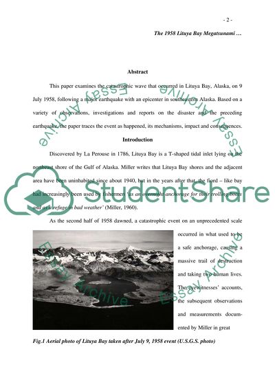
The 1958 Lituya Bay Megatsunami This paper examines the catastrophic wave that occurred in Lituya Bay, Alaska, on 9 July 1958, following a major earthquake with an epicenter in southeastern Alaska. Based on a variety of observations, investigations and reports on the disaster and the preceding earthquake, the paper traces the event as happened, its mechanisms, impact and consequences. Introduction Discovered by La Perouse in 1786, Lituya Bay is a T-shaped tidal inlet lying on the northeast shore of the Gulf of Alaska. Miller writes that Lituya Bay shores and the adjacent area have been uninhabited since about 1940, but in the years after that, the fiord – like bay had increasingly been used by fishermen ‘as an overnight anchorage for their trolling boats and as a refuge in bad weather’ (Miller, 1960). As the second half of 1958 dawned, a catastrophic event on an unprecedented scale occurred in what used to be a safe anchorage, causing a massive trail of destruction and taking two human lives. The eyewitnesses’ accounts, the subsequent observations and measurements docum-ented by Miller in great Fig.1 Aerial photo of Lituya Bay taken after July 9, 1958 event (U.S.G.S. photo) detail in his comprehensive report published by the U.S. Geological Survey, as well as the extensive survey conducted by Captain Elliot B. Roberts, all together, shed light on what had happened that day. On July 9, Pacific Standard Time, a major earthquake, with a magnitude of 7.9 on the Richter scale, although being reported by some sources as much as 8.3, occurred along the Fairweather Fault. The epicenter had been reported at latitude 58.6`N and longitude 137.1`W, at a point about 7.5 miles east of the surface trace of the Fairweather Fault and 13 miles southeast of the head of Lituya Bay (Brazee & Cloud, 1960). Based on the eyewitness accounts and on the field observations of his own on July 10, 1958, Miller stated that within 1 to 3 minutes after the earthquake, a giant wave front moved out from the head of the bay and ‘swept 7 miles along the shores to the mouth of Lituya Bay in about 4 minutes, destroying the forest over an area of 4 square miles and sinking two boats’ (Miller, 1960). Further in the same paper, Miller specified that due to the wave, the trees had been washed out to a maximum height of 1 720 feet, which is considered about eight times the maximum altitude of damage ever attributed to a tsunami or to a localized wave of any kind (Miller, 1960). The proposed mechanisms responsible for the giant, 1 720 feet wave have been an object of subsequent research and analyses, like those of Pararas-Carayannis (1999), Mader (1999), Mader and Gittings (2002), etc., undertaken in order to determine the most likely scenario that could account for the generation of the 1958 Lituya Bay mega-tsunami. Geography of Lituya Bay Don Miller describes Lituya Bay as ‘a T-shaped tidal inlet that transects the coastal lowland and foothills belt bordering the Fairweather Range of the St. Elias Mountains, on the northeast shore of Alaska’ (Miller, 1960). The stem of the letter T is formed by the main body of the inlet, which is seven miles long and two miles wide, with Cenotaph Island in its central part; the upper part of the T, which had been about 3 miles long in 1958, is formed by two other inlets – Gilbert Inlet and Crillon Inlet. The fiord-like inner part of the bay is surrounded by steeply rising walls – to elevations between 2 200 and 3 400 feet in the foothills and over 6 000 feet in the Fairweather Range (Miller, 1960). The shores surrounding the main part of Lituya Bay are predominantly stony beaches; the adjacent areas rise more gently from the beaches at varying gradients (Miller, 1960; Pararas- Carayan-nis, 1999). Two glaciers - Lituya Glacier Fig.2 Lituya Bay’s position on the map of Alaska and North Crillon Glacier - each one about 12 miles long and a mile wide, descend their fronts into the heads of Gilbert and Crillon Inlet respectively (Miller, 1960). About half of the front of Lituya Glacier and two-thirds of the front of North Crillon Glacier had bordered low deltas, before the July 9 earthquake and the wave that followed. A long spit - La Chaussee Spit – encloses the outer part of the bay, ‘with only a very narrow entrance of about 700 – 800 feet, kept open by tidal currents’ (Pararas-Carayannis, 1999). Bathymetry of Lituya Bay Based on soundings taken until 1940 (U.S. Coast and Geodetic Survey, 1942), Miller recorded that the maximum depth of the bay, just south of Cenotaph Island, is 720 feet and the minimum or sill depth is 33 feet at mean lower low water in the entrance (Miller, 1960). Describing the geography of Lituya Bay, Miller specified that the tides are diurnal, with a mean and a maximum range of about 7 and 15 feet respectively, and cause currents ‘with a maximum velocity of nearly 14 statute miles per hour in the narrow entrance’ (Miller, 1960) According to Pararas-Carayannis, who relies on the same bathymetric surveys made until1940, the head of Lituya Bay is ‘a pronounced U-shaped trench with steep walls and a broad, flat floor sloping gently downward from the head of the bay to a maximum depth of 720 feet(220 meters) just south of Cenotaph Island’(Pararas-Carayannis, 1999). Fig.3 Detailed map of head of Lituya Bay, showing site of the rockfall, landslides, changes in the shoreline (heavy dotted line), and extent of wave inundation (light dotted line) from the 1958 earthquake and the giant wave it triggered. Lighter barred line depicts shoreline just prior to the earthquake and wave (Modified after Miller, 1960) Geology of Lituya bay area Lituya Bay is inferred to have been a valley curved by glaciers, which had become a bay with the retreat of those glaciers, at the beginning of the Wisconsin interglacial period, some ten thousand years ago. The two arms at the head of Lituya Bay – Gilbert Inlet and Crillon Inlet – had been formed by the retreat of Lituya and North Crillon glaciers which have their origin near the crest of the Fairweather Mountains at heights of about 4 000 feet (Pararas-Carayannis, 1999). Miller regards both Gilbert and Crillon inlets as a part of a great trench – a topographic expression of a major fault first recognized by Mertie (Mertie, 1931), and later on named ‘the Fairweather fault’ (Miller, 1953). The fault plane is deemed vertical or dipping steeply northwest (Miller, 1960). According to Miller’s account, the bedrock on the steep slopes surrounding the inner part of the bay and on Cenotaph Island is exposed or covered by a thin layer of soil, glacial drift, or talus; the rocks at the head of the bay are predominantly amphibole and biotite schists; and ‘a sequence of complexly folded, slightly metamorphosed volcanic rocks, slate, and greywacke, with some granitic rocks, forms the spurs southwest of Gilbert and Crillon inlets’ (Miller, 1960). Tectonic setting of the region The tectonics of the region is dominated by the interaction between the Pacific and the North American tectonic plates. The boundary between the plates could be traced from the south, in the vicinity of California, marked by a large fault system which is the San Andreas Fault and a number of secondary faults; through the Cascadia subduction zone, which is immediately north of San Andreas; to further north along the west coast of Canada and Alaska where the Queen Charlotte - Fairweather fault system is Fig.4 Fairweather Fault on the map of Southeastern Alaska located. The Fairweather Fault is at the northern end of this long fault system that marks the eastern boundary of the Pacific plate and the western boundary of the North American plate. In this region, the movements of the two plates are as follows – the Pacific plate moves horizontally and northwestwards in relation to the North American plate, while the North American plate moves likewise, but in the opposite direction relative to the Pacific plate. These complex, irregular movements of the tectonic plates result in earthquakes along the faults, which are generally ‘strike-slip events and do not generate tsunamis’ (Pararas-Carayannis, 1999). Background information on past earthquakes and mega-tsunami events in Lituya Bay The earthquake of July 9, 1958 is considered the strongest one in the region since the great 1899, 8.2-magnitude, Cape Yakataga earthquake that occurred on the Fairweather fault and caused dramatic vertical changes. Within the twentieth century, there have been two other significant earthquakes along the Queen Charlotte – Fairweather fault system until July 9, 1958 – one in 1927, with magnitude 7.1 (Ms - surface wave magnitude), which occurred in the northern part of Chichagof Island and another in 1949 near the Queen Charlotte Islands, with magnitude 8.1 (Mw - moment magnitude) (Pararas-Carayannis, 1999). There are some indications that giant waves had repeatedly occurred in Lituya Bay, long before La Perouse – the explorer credited with the discovery of the bay - to report in his ship logs on the lack of vegetation on the sides of the bay "as though everything had been cut cleanly like with a razor blade"(Pararas-Carayannis, 1999). A Tlingit legend about a monster dwelling in the bay near the entrance had been recorded by Emmons in 1911 (Emmons, 1911; Miller, 1960). Other Indian stories about possible, yet not confirmed, giant wave occurrences which had caused various damage – from toppled canoes to the catastrophic destruction of a village near the entrance - along with the early explorers’ reports on the lines of cut trees, the dendrological evidence on old trees and dated trimlines, put together, support the occurrence of at least two other giant waves in Lituya Bay between 1854 and 1916 (Pararas-Carayannis, 1999). The last giant wave before 1958 occurred on October 27, 1936, whose mechanism of generation is not believed to have been associated either with an earthquake or a large subaerial rockslide, and left a line of uprooted trees to a maximum height of about 500 feet (Miller, 1960). The events in Lituya Bay on July 9, 1958 The earthquake and the following monster wave that occurred in Lituya Bay on July 9, 1958, had been witnessed by some of the fishermen who having anchored their trolling boats in the outer part of the bay, chanced to survive the disaster. According to them, the wave had been first sighted at the head of the bay within 1 to 3 minutes after the onset of the earthquake - about 10.18 pm local time – in fact, about sunset at this latitude and time of the year (Miller, 1960). The survivor H. G. Ulrich, whose boat ‘Edrie’, with his 7-year-old son on board, had been anchored near the south shore, about 2 miles from the entrance, describes the effects of the earthquake as violent shaking and heaving, followed by avalanching – in the mountains of the head of Lituya Bay’ (Miller, 1960), which had been followed by ‘deafening crash’ resembling an explosion, water dashing over the spur southwest of the inlet, and a wave coming out of the lower part. Ulrich described the wave as ‘a straight wall of water from shore to shore, possibly 100 feet high in the center’ (Miller, 1960). The wave had taken about 2 to 3 minutes after first had been sighted to reach the Ulrich’s boat ‘Edrie’; then the boat had risen with the wave whose front appeared to be very steep and some 50 to 70 feet high. Other survivors, W. A. Swanson and his wife, had anchored their boat ‘Badger’ in Anchorage Cove, near the north shore of the bay. Swanson described what he had seen on July 10, and in his words the Lituya Glacier’ … had risen in the air and moved forward so that it was in sight’ and in a while ‘the glacier dropped back out of sight and there was a big wall of water going over the point (the spur southwest of Gilbert Inlet)’ (Miller, 1960). The wave, according to Swanson account, had been about 50 feet high as it passed the Cenotaph Island in the center of the bay. Some 4 minutes after it had first been sighted, the wave reached ‘Badger’, lifted the boat up and carried it over La Chaussee Spit. The third trolling boat – ‘Sunmore’ – with Orville Wagner and his wife on board, had been anchored nearby the ‘Badger’, but had been nearer the entrance when the wave arrived. The boat sank with her crew (Miller, 1960). Fig.5 Extent and height of inundation by the giant wave generated in Lituya Bay on July 9, 1958 (modified graphic based on Millers 1958 Survey and Captain Roberts photogrammetry. The giant wave washed out trees to a maximum elevation of 1,720 feet (524 meters) at the entrance of Gilbert Inlet. Much of the rest of the shoreline of the Bay was denuded by the tsunami from 30 up to 200 meters in altitude. Findings on July 10, 1958 Don J. Miller and the pilot Kenneth Loken of Juneau flew over Lituya Bay for more than an hour on July 10, in order to photograph the bay at low altitude and to observe the after effects of the earthquake and the wave that occurred on July 9. According to Miller, apart from the destruction of vegetation, the most striking changes observed at the head of Lituya Bay had been the configurations of the front of Lituya Glacier and the northeast wall of Gilbert Inlet. A fresh scar marked the track followed by a huge mass of rock ‘that plunged down the steep slope into Gilbert Inlet’ (Miller, 1960). Subsequent measurements of the scar, which had been made from photographs, indicated that the rockslide had mainly come from elevations between 700 and 3000 feet on a 40o slope, and consisted of a rock mass estimated at about 40 million cubic yards/ 90 million metric tons (Miller, 1960). Fig.6 Stump of living spruce tree broken by Fig. 7 Another view of Lituya Bay from the 1958 giant wave at Harbor Point, mouth head of the Bay looking outwards, of Lituya Bay. Brim of hat is 12 inches in showing the effects of the giant waves diameter (University of California - Berkley photo). The front of Lituya Glacier had been found ‘a vertical, actively calving ice wall extending almost straight across Gilbert Inlet from the northwest margin of the rockslide scar (Miller, 1960). Based on a later comparison of photographs taken before and after the wave – on July 7 and July 10 respectively, Miller inferred that about 1 300 feet of ice had been cut from the front of Lituya glacier. The sharp trimline, below which the trees had been washed out and left scattered away ‘with limbs and roots removed and even bark peeled off down to the cambium’ (Miller, 1960), gave Miller a hint about the enormous energy of the wave (Miller, 1960). The only man-made structures in the area – a cabin on the west shore of Cenotaph Island and a small lighthouse at Harbour Point – had been wiped out in a way that ‘no trace of the foundations of these structures was left’ (Miller, 1960). Postulated mechanisms of generation of the 1958 megatsunami Based on his own observations of the 1958 giant wave after effects, as well as on the investigation of R. L. Wiegel of the Institute of Engineering Research, University of California, Miller concluded that the rockslide, under certain conditions, could have been the major cause of the wave (Miller, 1960). George Pararas-Carayannis has made the suggestion that a rockfall impact, similar to an asteroid impact caused the wave displacing the water in the inlet to the floor depth of 400 feet, near the landslide (Mader & Gittings, 2002). In the following sections are reviewed the possible mechanisms of the 1958 mega-tsunami generation. Tectonic mechanism The earthquake on July 9, 1958, which preceded the giant wave, has been associated with ground displacements that occurred in several pulses on magnitude of 21 feet horizontally and 3.5 feet upward. This had been measured on surface breakages along the Fairweather Fault, 5 miles southeast of Crillon Inlet (Tocher and Miller, 1959). Presumably, the southwest side and most of the bottom of Gilbert and Crillon inlets had moved northwest and up relatively to the northeast shore at the head of Lituya Bay, where the giant wave had been generated (Miller, 1960). Even if such a tectonic movement could have displaced enough water for the generation of a wave of this size and for the subsequent inundation of the bay, which is not the case, the wave generated in result of the tectonic displacement should have been directed toward the northwest and southwest side of Lituya Bay, and/or toward the head of the bay. The waves generated by the vertical displacement of the bottom of the bay along the Fairweather Fault would have come as from a line source across the entire head of Lituya Bay (Pararas-Carayannis, 1999). According the eyewitnesses’ accounts, the wave had first come in sight at the head of the bay between one and two and a half minutes after the onset of the earthquake (Miller, 1960). These accounts and the later observations have indicated that wave spread in a radial pattern of propagation starting form a point source in Gilbert Inlet. Given the above-said, the tectonic mechanism alone does not apply to be the main culprit for the disaster (Pararas-Carayannis, 1999). Sudden glacial lake drainage mechanism The existence of a partly subglacial lake just northwest of the sharp bend of the Lituya Glacier, at the head of Lituya Bay, along with the observation made that the lake level had lowered with about 100 feet after the earthquake, have suggested such a mechanism as the cause of the 1958 wave. Hypothesizing about the generation of the wave from this mechanism, George Pararas-Carayannis (1999) has pointed out the pros and cons as follows: A great volume of water would be needed to be collected in a chamber at a height enough to produce the necessary hydraulic head. A strong enough impulsive triggering mechanism is also required to cause the sudden drainage of this water volume into Gilbert Inlet. Considering both above-mentioned prerequisites to have been partly available, there was no physical evidence that such drainage of the lake on the surface of Lituya Glacier had occurred. Even if such drainage could have occurred in front of Gilbert Glacier, the maximum height of the wave would have been expected on the opposite side in Crillon Inlet, rather than at the spur on the southeastern corner of Gilbert Inlet. The lowering of the glacial lake level, after the earthquake on July 9, could be attributed to a large volume of water that had been drained through a glacial tunnel into the inlet, resulting in sudden water swelling in front of the glacier. However, it’s largely believed that neither the water volume nor the rate of the drainage had been sufficiently high to account for the initial 1 720 ft. wave, as well as for the subsequent inundation in the bay (Pararas-Carayannis, 1999). Landslide mechanism Observations made and photographs taken from an airplane on July 10, 1958, as well as the examinations on the ground later in the summer of 1958, confirmed that the maximum height of destruction due to the 1958 giant wave of 1 720 feet in Lituya Bay, have exceeded everything seen and recorded to that point (Miller, 1960) Given that no one known landslide has ever triggered a wave which could approach the magnitude of the one in Lituya Bay, plus the fact that the landslides are generally considered not very effective mechanisms for tsunami generation, it’s very unlikely the landslide mechanism alone to have been responsible for the 1958 mega-tsunami generation (Pararas-Carayannis, 1999). Impulsive rockfall impact mechanism Don Miller first concluded that an enormous mass of rock estimated at about 40 million cubic yards/ 90 million metric tons, which hit the surface of Gilbert Inlet, might have caused the giant wave, ‘if it fell almost as a unit and very rapidly’ (Miller, 1960). Further investigations of the nature and cause of the 1958 wave, as that conducted by R. L. Wiegel of the Institute of Engineering Research, University of California, as well as the reproduction of the Lituya Bay event, in the summer of 2000 by Hermann Fritz, indicated that the 1958 giant wave, which splashed on the spur of Gilbert Inlet at maximum height of 1 720 feet, could be caused by a landslide impact (Mader & Gittings, 2002). According to this scenario, the maximum run-up of the wave at the head of Lituya Bay and the subsequent huge wave that run across the main trunk of the bay had been caused mainly ‘by the enormous subaerial rockfall into Gilbert Inlet’ (Pararas-Carayannis, 1999). While the landslide presents a gradual process, the giant rockfall, as it occurred in Lituya Bay, is a very sudden event, which has been triggered impulsively (Pararas-Carayannis, 1999). In this way, the term impulsive rockfall has been used to explain the sequence of events that happened afterward. The explosion-like sound heard by Ulrich is attributed to the impact of this mass of rock onto the water surface; the rockfall impact is considered not only to have displaced with great force the water but also to have created a large radial crater in the bottom of Gilbert Inlet, displacing ‘an equivalent volume of recent glacier sediments and deeper semi-consolidated Tertiary layers’ (Pararas-Carayannis, 1999). Fig. 8 Illustration of the impulsive rockfall impact mechanism scenario Thus the rockfall impact had generated a non-linear wave, ‘which splashed as a sheet of water’ on the other side of Gilbert Inlet at a height of 1 720 feet, in fact three times the actual water depth (Pararas-Carayannis, 1999). With the contribution from the vertical 3.5 ft. ground displacement and the overall movement seaward of the entire Lituya Bay’s crust block, the rockfall impact had generated a solitary gravity wave, which originated in Gilbert Inlet and propagated from the head of the bay outward with estimated height of about 100 feet or even more. According to George Pararas-Carayannis, this mechanism is the most likely (the PC model) one that could account for the giant wave in 1958 (Pararas-Carayannis, 1999). The PC scenario had been modeled with full Navier-Stokes AMR (Automatic Mesh Refinement) Eulerian compressible hydrodynamic code called SAGE including the effects of gravity (Mader & Gittings, 2002). The modeling supported the impulsive rockfall impact mechanism and further illustrated that the volume of the water had been sufficient for the giant wave to occur. Remedial action that was, or could have been, taken to predict, prevent, or reduce the problem Due to the unique combination of the geologic and tectonic conditions of Lituya Bay, along with the fact that similar, although not on that massive scale, events had repeatedly occurred in the bay, there is no doubt about the occurrence of such events in the future. As a cliché says – it’s not a question of if, but of when. Unfortunately, just like in the case of the volcanic eruptions and the major earthquakes, to be predicted a disaster is one thing, to occur as predicted - another, but to be prevented the catastrophe is a bit of unscientific fiction. Therefore, the only possible counter-action appeared to be the restriction of human settlement in high risky areas. Conclusion An enormous mass of rock, estimated at about 40 million cubic yards/ 90 million metric tons, acting as a monolith, hit the surface of Gilbert Inlet on July 9, 1958. This resulted in water splashing action on the other side of Gilbert Inlet at maximum height of 1 700 feet (Pararas-Carayannis, 1999). The rockfall impact in combination with the crust movements – the 3.5 ft. vertical and the overall tilting seaward – appeared to be the actual culprit for the generation of the giant gravity wave which subsequently swept the main trunk of Lituya Bay. Given the total loss inflicted on man and the man-made structures – one-third of the population (two people drown out of six) and almost 100 percent of the structures (Miller, 1960) – along with the real possibility such events to occur in future, present a reasonable indication of what would be the catastrophic consequences if something similar - an asteroid crash for instance – occurred in a permanently inhabited area. Bibliography {1} Miller, Don J., 1960, The Alaska Earthquake of July 10, 1958: Giant Wave in Lituya Bay, Bulletin of the Seismological Society of America, Vol.50, No 2, pp 253-266 {2} Emmons, G. T., 1911, Native account of the meeting between La Perouse and the Tlingit: Am. Anthropologist, n. ser., v. 13, pp. 294 - 298. {3} Pararas-Carayannis, George, 1999, Analysis of Mechanism of Tsunami Generation in Lituya Bay, Science of Tsunami Hazards, The International Journal of the Tsunami Society, Vol. 17, No 3, p 195, retrieved on 26/11/2010 < http://library.lanl.gov/tsunami/> {4} Brazee & Cloud, 1960, U.S. Earthquakes 1958, U.S. Dept. of Com. Coast & Geodetic Survey 76 pp. {5} Miller, Don J., 1954, Cataclysmic Flood Waves in Lituya Bay, Alaska, Bull. Geol. Soc. Am. 65, 1346 {6} Miller, Don J., 1953, Preliminary Geologic Map of Tertiary Rocks in the Southeastern Part of the Lituya District, Alaska, U.S. Geological Survey, Open-file Report {7} Miller, Don J., 1960, Giant Waves in Lituya Bay, Alaska, Geological Survey Professional Paper 354-C, U.S. Government Printing Office, Washington {8} Mader, Charles L. and Gittings, Michael L., 2002 Modeling the Lituya Bay Mega-tsunami II, Science of Tsunami Hazards, Volume 20, Number 5, page 241, retrieved on 26/11/2010 {9} Mertie, J.B., Jr., 1931, Notes on the Geography and Geology of Lituya Bay, U.S. Geological Survey, Bull.836-B, pp 117 - 135 {10} Haynes, Vi, Night of Terror, Alaska Sportsman, 24(No 10); 11, 42-44 {11} Tocher, D. and Miller, D.J, 1959, "Field observations on effects of Alaska earthquake of 10 July, 1958", Science, v. 129, no. 3346, pp 394-395. Figure References Figure 1. Aerial photo of Lituya Bay taken after July 9, 1958 event (U.S.G.S. photo), retrieved on 26/11/2010 < http://www.drgeorgepc.com/Tsunami1958LituyaB.html> Figure 2. Lituya Bay’s position on the map of Alaska, retrieved on 26/11/2010 < http://www.drgeorgepc.com/Tsunami1958LituyaB.html> Figure 3. Detailed map of head of Lituya Bay, showing site of the rockfall, landslides, changes in the shoreline (heavy dotted line), and extent of wave inundation (light dotted line) from the 1958 earthquake and the giant wave it triggered. Lighter barred line depicts shoreline just prior to the earthquake and wave (Modified after Miller, 1960), retrieved on 26/11/2010 < http://www.drgeorgepc.com/Tsunami1958LituyaB.html> Figure 4. Fairweather Fault on the map of Southeastern Alaska, retrieved on 26/11/2010 < http://www.drgeorgepc.com/Tsunami1958LituyaB.html> Figure 5. Extent and height of inundation by the giant wave generated in Lituya Bay on July 9, 1958 (modified graphic based on Millers 1958 Survey and Captain Roberts photogrammetry. The giant wave washed out trees to a maximum elevation of 1,720 feet (524 meters) at the entrance of Gilbert Inlet. Much of the rest of the shoreline of the Bay was denuded by the tsunami from 30 up to 200 meters in altitude, retrieved on 26/11/2010 < http://www.drgeorgepc.com/Tsunami1958LituyaB.html> Figure 6. Stump of living spruce tree broken by 1958 giant wave at Harbor Point, mouth of Lituya Bay. Brim of hat is 12 inches in diameter, retrieved on 26/11/2010 < http://www.allvoices.com/contributed-news/6682930-most-terrifying-natural-disasters-in-history/image/62917410-the-1958-lituya-bay-megatsunami> Figure 7. Another view of Lituya Bay from the head of the Bay looking outwards, showing the effects of the giant waves (University of California - Berkley photo), retrieved on 26/11/2010 < http://www.drgeorgepc.com/Tsunami1958LituyaB.html> Figure 8. Illustration of the impulsive rockfall impact mechanism scenario, retrieved on 26/11/2010 < http://www.drgeorgepc.com/Tsunami1958LituyaB.html> Read More
Tags
Cite this document
  • APA
  • MLA
  • CHICAGO
(“The 1958 Lituya Bay Megatsunami Term Paper Example | Topics and Well Written Essays - 2500 words”, n.d.)
The 1958 Lituya Bay Megatsunami Term Paper Example | Topics and Well Written Essays - 2500 words. Retrieved from https://studentshare.org/miscellaneous/1572835-the-1958-lituya-bay-megatsunami
(The 1958 Lituya Bay Megatsunami Term Paper Example | Topics and Well Written Essays - 2500 Words)
The 1958 Lituya Bay Megatsunami Term Paper Example | Topics and Well Written Essays - 2500 Words. https://studentshare.org/miscellaneous/1572835-the-1958-lituya-bay-megatsunami.
“The 1958 Lituya Bay Megatsunami Term Paper Example | Topics and Well Written Essays - 2500 Words”, n.d. https://studentshare.org/miscellaneous/1572835-the-1958-lituya-bay-megatsunami.
  • Cited: 0 times

CHECK THESE SAMPLES OF The 1958 Lituya Bay Megatsunami

Brown vs. Board of Education

?? (Ziegler, 1958 pg.... (Ziegler, 1958 pg.... Instructor name Date Brown vs.... Board of Education The United States was founded on the idea of equality and justice for all, at least for white, male property owners.... This lofty concept was novel for the times and eventually evolved to include minority members and women....
3 Pages (750 words) Essay

Dwight Eisenhower as One of Americas Greatest Presidents

In 1956, Dwight Eisenhower managed to convince Israel, France and the United Kingdom to end their occupation of Egypt, and in 1958, he supported the Lebanese government from a revolution instigated by Nasser, the president of Egypt.... Dwight Eisenhower was the 34th president of United States of America, and his presidency occurred between the periods of 1953 to 1961....
3 Pages (750 words) Essay

Biography on Abraham Lincoln

Patrick Kennedy was a businessman and a ward politician who had high contacts in Boston.... Joseph Kennedy was the son of Patrick Kennedy who married the daughter of Mayor Fitzgerald named Rose Fitzgerald.... hellip; Robert Kennedy was born in Brooklyn in the year of 1925.... Born in Brooklyn Robert had to change many homes before ending up in Bronxville....
5 Pages (1250 words) Essay

The Life of Sir Alexander Fleming

Fleming passed with distinction in 1906 and started research at St.... Marys under the tutelage of Sir Almroth Wright, a pioneer in vaccination.... At St Marys Hospital Medical… , he exceeded expectations, rapidly demonstrating his manual expertise and creativeness; to such an extent that for some time it looked as though a future in surgery efforts until he was attracted to the microorganisms hunting and helpful research work....
4 Pages (1000 words) Essay

Canada Unemployment Rate from 1950-2014

This research is being carried out to evaluate and present Canada unemployment rate from 1950-2014 by such age groups as 15-24; 25-44; 45-64; 65-69.... This essay also explores the unemployment rate by gender and geographical region.... hellip; According to the diagram presented in this research, it is evidently clear that unemployment rate in Canada has grown across all age groups from 1950 to 2014....
1 Pages (250 words) Assignment

Arab Nationalism through Nasser's mind

The bond of this nationalism begins from the Atlantic Ocean to the Arabian Sea, in context to its culture, religion, historical heritage and common linguistic.... The major motive of Arab nationalism is… The most highlighted personality considering the Arab nationalism is ‘Gamal Abdul Nasser'....
6 Pages (1500 words) Research Paper

A illustrated time line 1945 1997

The Conservatives leader Harold Macmillan won the general election with great margin of votes in 1958 and gained 365 seats, whilst Labour gets 258 seats.... In 1945, Britain, still had the largest empire in the world and was granted independence by 1964.... In 1952, it became the third state in the world to… Moreover, it became a member of international organizations, such as United Nations and held a seat on the Security Council....
1 Pages (250 words) Coursework

History Of The Allis Chalmer Tractor and its Uses

The author examines Allis Chalmers Tractors company which performance was very impressive and by 1979 it had grown into about $2 billion Company and was one of the most significant tractors manufacturers in the US.... The company officially called off it a business of equipment manufacturing in 1998… The Allis-Chalmers company was located in West Allis, Wisconsin....
6 Pages (1500 words) Research Paper
sponsored ads
We use cookies to create the best experience for you. Keep on browsing if you are OK with that, or find out how to manage cookies.
Contact Us