StudentShare
Contact Us
Sign In / Sign Up for FREE
Search
Go to advanced search...

Global Positioning System - Essay Example

Cite this document
Summary
As is widely known, GPS is a satellite based navigation system developed and maintained by the US DOD broadcasting signals in L1 and L2 bands. It is widely used for many purposes including air and ground navigation, volcano deformation monitoring, fault deformation and plate motions…
Download full paper File format: .doc, available for editing
GRAB THE BEST PAPER92% of users find it useful
Global Positioning System
Read Text Preview

Extract of sample "Global Positioning System"

Download file to see previous pages

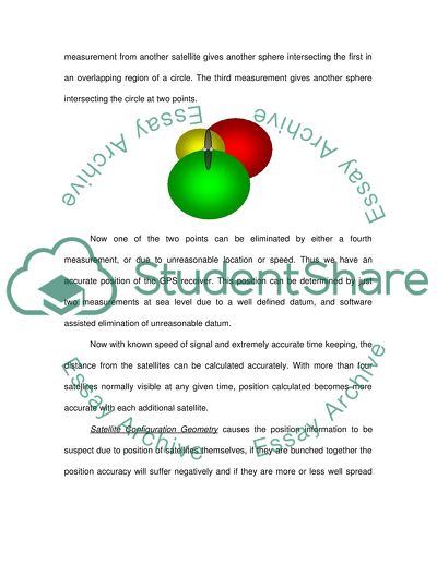
The system calculates the position of the receiver by Triangulation method, which is similar to manner in which a seismologist locates position of an earthquake epicentre using arrival time of seismic waves. When distance from one satellite is measured, the position gives us radius of a sphere. Similar measurement from another satellite gives another sphere intersecting the first in an overlapping region of a circle. The third measurement gives another sphere intersecting the circle at two points.

Now one of the two points can be eliminated by either a fourth measurement, or due to unreasonable location or speed. Thus we have an accurate position of the GPS receiver. This position can be determined by just two measurements at sea level due to a well defined datum, and software assisted elimination of unreasonable datum. Now with known speed of signal and extremely accurate time keeping, the distance from the satellites can be calculated accurately. With more than four satellites normally visible at any given time, position calculated becomes more accurate with each additional satellite.

Satellite Configuration Geometry causes the position information to be suspect due to position of satellites themselves, if they are bunched together the position accuracy will suffer negatively and if they are more or less well spread out in space, the accuracy is much better. This aspect is called Dilution of Position (DOP). GPS Signa Limitations and Future of GPS There are some inherent limitations of the GPS as given below:GPS Signal Reception. Accurate functioning of a GPS receiver requires at least four GPS satellites.

These signals cannot penetrate water or soil. Hence, GPS cannot be used for underwater marine navigation or underground surveys like mines or tunnels. Similarly, in areas of skyscrapers or high surrounding terrain, the number of visible satellites or signal strength can fall below acceptable strength hampering GPS functioning.GPS Signal Integrity Monitoring. Since the datum for all calculations is GPS satellite, wrong satellite positions or wrong range measurements from satellites can be potentially disastrous.

Thus GPS Integrity Channel (GIC) and Receiver Autonomous Integrity Monitoring (RAIM) are two schemes to accurately monitor integrity of signal information and warn the receiver whenever a conflict situation exists.GPS Signal Accuracy. A GPS receiver normally measures time taken for a signal to arrive at the receiver and converts it into range information. This measurement can be corrupted in many ways called collectively as User Equivalent Range error (UERE). These are corrected by directly deducting the known error from the calculations or reduce these errors by changing the way we make measurements.

Uncorrected errors creep into the calculations causing different kinds of inaccuracies or errors affecting performance of the receiver. The future looks good with intense competition among world players to have their own GPS, mainly due to security aspirations. Russia, Europe and Japan are currently in advanced stage of system development/testing and many other regional countries are thinking about their own GPS. This would also lead to better accuracy and world wide acceptance of GPS for commercial and city use.

The advantages would be better prices, more redundancy especially in the field of aviation and extensive market penetration due to hand held ground based GPS. The

...Download file to see next pages Read More
Cite this document
  • APA
  • MLA
  • CHICAGO
(“Global Positioning System Essay Example | Topics and Well Written Essays - 1250 words”, n.d.)
Global Positioning System Essay Example | Topics and Well Written Essays - 1250 words. Retrieved from https://studentshare.org/miscellaneous/1527916-global-positioning-system
(Global Positioning System Essay Example | Topics and Well Written Essays - 1250 Words)
Global Positioning System Essay Example | Topics and Well Written Essays - 1250 Words. https://studentshare.org/miscellaneous/1527916-global-positioning-system.
“Global Positioning System Essay Example | Topics and Well Written Essays - 1250 Words”, n.d. https://studentshare.org/miscellaneous/1527916-global-positioning-system.
  • Cited: 0 times

CHECK THESE SAMPLES OF Global Positioning System

Global Positioning Systems

Air Force initiated the 24th Navstar satellite achieving a network of 24 satellites now known as the Global Positioning System or GPS (Kleppner, n.... In short, the tracking system in both privately owned and for commercial purposes, the information obtained from the tracking GPS is usually used in cases of stealing, and security preventions.... The GPS system applied in aviation represents a cornerstone of the forthcoming air traffic management....
4 Pages (1000 words) Essay

Huffman Trucking - Tools For Business

The Global Positioning System can be used as a tool.... And to see that the objective is met, one tool that can be used to evaluate, monitor and at the same time improve the quality and raise productivity of the business is: Global Positioning System: The Global Positioning System can be used as a tool that can incorporate all other data from different traditional process improvement tools.... To further improve the quality of service the business provides, the use of Global Positioning System or GPS is recommended to be added to the process improvement tools....
2 Pages (500 words) Essay

Global Positioning System

Moreover, the Global Positioning System operates in any weather state, anywhere in the globe, 24 hours a day.... This paper presents a detailed overview of Global Positioning System.... This paper will outline the history, advantages and disadvantages of the Global Positioning System.... Initially GPS system was designated the navigation system with timing and ranging (or NAVSTAR) Global Positioning System.... In addition, with the development of Global Positioning System it has become an integral asset in several civilian applications as well as industries around the world, comprising recreational utilization (for example aircraft, boating, hiking), business vehicle fleet tracking, as well as surveying....
6 Pages (1500 words) Term Paper

GPS And Its Use In Modern Surveying

The Global Positioning System (GPS) is a system of satellite navigation that is space-based and provides information about time and location of a region in all kinds of weathers.... hellip; “The technology operates on the principle of triangulation—if the difference from an observer to three known points can be measured, the position of the observer can be calculated” (“Global Positioning System”).... GPS And Its Use In Modern Surveying The Global Positioning System (GPS) is a system of satellite navigation that is space-based, and provides information about time and location of a region in all kinds of weathers provided that an unobstructed line of sight is present to at least four GPS satellites....
1 Pages (250 words) Essay

The history and the future of GPS

GPS stands for Global Positioning System which is based on the navigation satellites.... The Global Positioning System provides information related to time and location.... It is a satellite navigation system which works well in all weather conditions on and close to the earth (Global Positioning System).... GPS has played vital role in modernizing the Air Traffic system and it has benefitted the military, army, civil and commercial users all around the world....
5 Pages (1250 words) Research Paper

The Holographic Global Positioning System Interface

This paper "The Holographic Global Positioning System  Interface" focuses on the intelligent location of the vehicle and navigation information that will enable the users to avoid the freeway.... This is through using the Global Positioning System.... The Holographic Global Positioning System will offer the answers in facilitating all these concerns.... he Holographic Global Positioning System will offer the intelligent location of the vehicle and navigation information that will enable the users to avoid freeway that is congested....
14 Pages (3500 words) Assignment

Global Business Plan of Garmin Global Positioning System

The paper aims to devise a comprehensive business plan for Garmin Global Positioning System, which looks for launching its business in the Far Eastern country of Taiwan.... nbsp;Garmin Global Positioning System is the world famous brand that has introduced wonderful devices related to navigation and communication and hence brought revolutionary developments in the field of information technology and communications....
13 Pages (3250 words) Term Paper

Methods of Georeferencing

When employing the direct method, the accuracy of the ground object coordinate relies on the Global Positioning System for the position and heavily on the Integral Measurement Unit for accurate orientation.... irect Georeferencing commonly denoted by (DG) is used to refer to a system having the capacity to directly associate data collected by a sensor remotely from the earth's surface.... The system does this by precisely taking the measure of the geographical position and the orientation of the remote gadget eliminating the use of aged control points, which are based on the ground....
11 Pages (2750 words) Case Study
sponsored ads
We use cookies to create the best experience for you. Keep on browsing if you are OK with that, or find out how to manage cookies.
Contact Us