StudentShare
Contact Us
Sign In / Sign Up for FREE
Search
Go to advanced search...
Free

The Blue Ridge Parkway - Research Paper Example

Cite this document
Summary
From the paper "The Blue Ridge Parkway " it is clear that generally, the Parkway has restored or added cultural attractions, such as the Blue Ridge Music Center at the midpoint of the Parkway that features concerts in the outdoor amphitheatre (Beric 8)…
Download full paper File format: .doc, available for editing
GRAB THE BEST PAPER92.4% of users find it useful
The Blue Ridge Parkway
Read Text Preview

Extract of sample "The Blue Ridge Parkway"

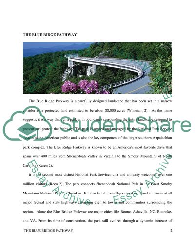
The Blue Ridge Parkway is a way through a park with boundaries surrounding the entire landscape. The Parkwayis owned and managed by the National Park Service system of the American public and is also the key component of the larger southern Appalachian park complex. The Blue Ridge Parkway is known to be an America’s most favorite drive that spans over 400 miles from Shenandoah Valley Virginia, to the Smoky Mountains of North Carolina. It is the second most visited National Park Services unit and annually welcomes over one million visitors. It is fed all rounds by several exits and entrances at all major federal and state highways extending even to towns and communities surrounding the region. THE BLUE RIDGE PATHWAY The Blue Ridge Parkway is a carefully designed landscape that has been set in a narrow corridor of a protected land estimated to be about 88,000 acres (Whisnant 2). As the name suggests, it is a way through a park with boundaries surrounding the entire landscape designed to present and protect the Pathway. The park is owned and managed by the National Park Service system of the American public and is also the key component of the larger southern Appalachian park complex. The Blue Ridge Parkway is known to be an America’s most favorite drive that spans over 400 miles from Shenandoah Valley in Virginia to the Smoky Mountains of North Carolina (Karen 2). It is the second most visited National Park Services unit and annually welcomes over one million visitors (Reco 2). The park connects Shenandoah National Park in the Great Smoky Mountains National Park in Cherokee. It I also fed all round by several exits and entrances at all major federal and state highways extending even to towns and communities surrounding the region. Along the Blue Bridge Parkway are major cities like Boone, Asheville, NC, Roanoke, and VA. From its time of construction, the park still evolves through a dynamic increase of relationships in different facets. For instance, there is a continuous change in the landowners, the surrounding communities, and the public (Whisnant 2). Winding its way through 12 Virginia and 17 North California counties, it is characterized by beautiful and uncountable Appalachian landscapes. It is also surrounded by numerous communities with a profound impact on their social, economic, and cultures. The construction of the Pathway was a product of President Franklin D. Roosevelt and the Great Depression’s New Deal Programs to provide employment to the people to boost the economy of the United States. As the primary stakeholders of the program, they initiated the connection of the Great Smokies and Shenandoah that was authorized in 1920s, but opened in 1930s (Beric 1). The program was part of the States’ effort to bring together a full connection of national parks to the population centers in Eastern US. The construction work begun in 1935, and was fully completed in 1987 when the final section, “the missing link” around Grandfather Mountain in North Carolina ended (Whisnant 3). Initially, its construction was funded by the Public Works Administration of the Federals but later drew monies and manpower from other New Deal agencies (Reco 3). These organizations included the Civilian Conservation Corps, Resettlement Administration, and the Works Progress Administration that all worked together on the New Deal’s development projects of the signature park. The construction process however came to a halt in 1943 as a result of World War 2 when the work was under way covering about 330 miles. Out of this length, only 170 miles had been paved and open for travel. After that, a large portion of the funding to end the road was sourced from MISSION 66 park-enhancement program that completed the Grandfather Mountain section in 1966. Linn Cove Viaduct was then created to enable the Parkway to pass the Grandfather Mountain without causing any damage to the rugged terrain. After the installation of the viaduct, the Great Smoky Mountains, and the Shenandoah National Park were forever linked to bring the total connection of the Pathway between North Carolina and Virginia (Catlin, 2). Civilization of construction The culture and civilization of the 1930s were that of evolution and change in different social, cultural and economic developments. The population of the Northern Carolina was by then approximately 35,045,234 (Whirtsmart et al. 3). At the same time, there were many immigrants of the Tutelo Indians and Chinese immigrants who interacted with the Cherokee Indians, Saponi, and Monacan of the Northern Carolina and Western Virginia. Building and construction of the Pathway involved a cooperative effort of many agencies, hands, and individuals at the state, federal, and local levels. The states of Virginia and North Carolina acquired most of the land that they deeded to the federal government while another portion of the land was given to the park by the Forest Service Unit of the United States (Osment 5). Parkway engineers and designers and the National Park Service architectures worked together in laying out the route and carefully crafting a planned landscape highlighting glorious mountain vistas. Together, they invited travelers to discover dramatic and secluded waterfalls, open great picture windows into an idealized rural pioneer America (Catlin 4). Also involved were the private road-building constructors, Civilian Conservation Corps, and Civilian Public Service, who groomed and shaped the landscape while building the visitor facilities. In order to preserve the scenic experience in the Pathway, it was planned that will be a limited-access and a non-commercial road, bounded by 800-100 feet wide right-of-way (Catlin, 4). The project resulted in the construction and production of a beautiful Parkway for travelers, but sparked a significant conflict with landowners whose lands were threaded by the road. Other naturally existing sceneries and the beautiful landscapes were also destroyed by the heavy machinery that was used to pave a way for the road construction (Whirtsmart et al. 5). The destruction also led to the interferences of different floral and faunal way of life. Their breeding sites were destroyed forcing other wildlife to migrate to other areas. Prevalent culture during construction The Parkway community was characterized by the Cherokee Indians of the Northern Carolina, and the Saponi, Monacan, and the Tutelo Indians of the Western Virginia. These communities were among the earliest people who inhabited the Blue Ridge Parkway leaving changes and artifacts in the landscape, which provides evidences of their existence in the area (Beric 9). Until today, most of these evidences are still visible at the mountain base that dates back in the old centuries. They are directly related to the ancient agricultural methods of burning and tree and underbrush dreading to provide croplands and grazing fields that were characteristic of the American Indian communities. The rivers and the mountains naming along the Parkway also reflects an influence of the American Indian community. Some of their tools and equipment they used like arrowheads are still kept in the Peak of Otter Visitor Center Museum (Reco 2). Since the year 1946, the Blue Ridge Parkway remains one of the most visited sites in the entire systems of the National Park. Driving through it gives one an opportunity to a physically experience traveling through unfolding series of breath-taking landscapes (Reco 6). It is also characterized by well-designed peaceful farm scenes with carefully selected views far and near. The scenic road was also thoughtfully designed on the land making it appear like it has always existed. Creating a great impact in discovery, the Parkway conceals many elements of disruption and social conflicts. It hence allows researchers, students, and digital tourists to hear unforgettable voices and uncover hidden stories. It hence gives them an excellent opportunity of understanding the often wretched construction choices and scenic preservation entailing this populated region (Amberg 2). Famous attraction sites along the Blue Ridge Parkway Along the Parkway are split-ray fences, mountain meadows, old farmsteads, and scenic overlooks characterized by endless vistas that make it a favorite attraction site. It incorporates numerous picnic areas, campgrounds, and trails (Beric 11). At different milepost along the western North Carolina section, the Pathway displays the Grandfather Mountains, Visitor Center, Folk Art Center, and Mt. Mitchell that is the tallest mountain in the east of Mississippi. Also evident are the Craggy Gardens hiking and picnic areas, Pisgah Inn restaurant, and the North Carolina Arboretum. In viewing the Western part of North Carolina, the Parkway offers classic overlook points like the Graveyard Field, Looking Grass Rock, and the Cold Mountain overlooks (Osment 7). Fig 1: The Blue Ridge Parkway (Adopted from North California Photographic archives; Wilson Library) The building and construction of the Parkway The completion of construction of the Blue Ridge Parkway took more than 52 years with the last stretch laid around the Grandfather Mountain in 1987. Twenty-seven tunnels were constructed through the rock, 26 in North Carolina and one in Virginia as shown in figure 2, with sections of the Parkway near the tunnel often closed during the winter season (Osment 9). The Parkway also uses short side roads that connect to other highways hence creating lovely wildlife scenery and beautiful landscapes without having to stop for cross-traffic. The mileposts along the Parkway begin at zero along the north eastern side of Virginia counting through to 469 at the southern end of North Carolina. Major cities and towns along the Parkway include Roanoke, Waynesboro, and Galax in Virginia, where it runs through the Biltmore Estate property. The Blue Ridge Music Center is located in Mount Mitchell and Galax, which can only accessed via a state road from the Parkway 355.4 miles away (Reco 7) Fig 2. Tunnel construction through a rock Tools and equipment used in the construction process employed shovel dozers with large blades able to peel layers of soil and push it away as the tractor was moving. Mowing equipment mounted with grass blades and bush hogs helped in grooming and the upkeep of the parkway (Whirtsmart et al.8). Shovels helped in accessing the rock to be hauled away after blasting to give way to the heavy-duty trucks to haul the large loads away to other locations or for crushing for reuse in the construction. Large dump trucks with loads of gravel provided strong foundations for the construction of the roadbed. It was getting leveled once packed, and asphalt added which made it more efficient in its functioning (Beric 5). Fig 2: The Blue Ridge Parkway Construction (Adopted from North California Photographic archives; Wilson Library) Quality control crews were also involved in preparation of asphalt repair, determination of the correct type of material before the process commences, and the degree of thickness the material will be covering the surface. They also conducted the survey to determine the correct width of the road built. (Karen 5).The dump trucks with gravel spreader were used to pull a gravel spreader, thereby moving the levers, thus allowing the gravel to spill smoothly on the road. Three-wheel road rollers were used for compacting the already spread gravel hence helped the gravel attain the required thickness and smoothness (Osment 6). Seal coating was also used in spraying asphalt seal over the layer of asphalt to correctly seal any form of crack on the road element. Track tractor hauling helped in blasting of the rock to small pieces that could be easily picked by the shovel in the foreground and loaded on the truck tractor. Road strip equipment helped in marking the traffic lines on the road, such as placing the single white line on the center of the road. A moving bridge girder was used to assist in maneuvering along the parkway since the crew had to handle monster over hills or around corners to get in place (Beric 7). Bucket excavators used by contractors helped in speeding the process of building the Blue Ridge Parkway. Shovel excavator loading trucks also helped in loading large boulders from the site. Also used were, rugged dump truck, asphalt paving truck, shovel excavator loading truck, as well as bucket excavator (Karen 11). Construction materials used included the gravel, sand and cement that were used to make concrete. The steel metal was used to provide support for the concrete used. Timber formed the pier where the concrete was mixed on the site and hauled up to the area that needed to have the concrete; it also provided the support to the concrete before sticking together (Beric 9). The blasted rocks were used in building the gabions to control the mass wasting of the parkway boundaries. Cameras were also used to take photos of the progress of work and sent back to the designers, engineers, as well as the architectures. Construction method covered the techniques and procedures that were used while double piers were built to offer support for the round meadows via duct near the milepost (Catlin 9). The large portion of the labor force was made up of Chinese immigrants who worked on the construction of the Blue Ridge Parkway. During the construction period, these people lived in construction camps that were constructed along the highway depending on the activity they covered from time to time (Osment 6). During these early days, there was not many equipment or tools other than picks, shovel, and dynamite that were used to explain obstacles across the landscape in the desired routes. The workers were often subjected to extreme challenges and conditions like severe weather, terrains not easily accessible, and thick forests among others (Karen 12). The design and construction process brought together different stakeholders running from engineers, architecture, surveyors, economists, designers and the unskilled workforce. As the designs developed the proper construction methods, shareholders to be adopted by the engineer went ahead selecting and taking the routes that were to be bridge parkway. Graders prepared the park beds for the trucks, blasted through rocks and filling valleys that would inconvenience the construction. The task force would then follow to lay the bedrock foundation while dumping the gravel and sand to hold the development together (Catlin 1 0). The site that marks the commencement of the Blue Ridge Parkway construction is an unassuming roadside plaque that is a few hundred yards from the Virginia-North Carolina border near Cumberland Knob. At this point, the low profile looks appropriate with a subtle pleasure that harks back to the time when traveling was not just about the destination but the journey (Karen 13). It was the first of the initial 45 segments of the Parkway tracing the 469 undulating miles from the Rockfish Gap. It is at this point that it connects to the Skyline Drive of the Shenandoah National Park through to North Carolina, Cherokee, and to the eastern entrance of the Great Smoky Mountains National Park (Amberg 9). The ultimate crooked road dips into river valleys, tops mountain crests and meanders through the national forests and farmlands. It passes through four major rivers and six mountain ranges and drops to 649 feet above the sea level near James River in southwest Virginia. It then climbs a 6,053 feet near Mount Pisgah in the North Carolina has shown a vast range of ecosystems (Beric 23). The Parkway was envisioned by the parkways as a new kind of road purposefully for the tourist recreation. It was distinguished from the purpose of regional travel a guided by the vision guide and central themes on the design of the Blue Ridge Parkway (Karen 13). Entrances to the Blue Ridge Parkway regularly appear but do not cause any obstruction to the civilization of the Parkway. The Parkway hence eliminated the insightful and parasitic border development of the gasoline shack, hot-dog stand, and the billboard leading to the prevailing natural scenery (Whirtsmart et al. 8). Analysis of the possible current construction styles The modern architectural and the infrastructure involvements in the design and construction of bridges have undergone significant development in the recent years. Many construction companies have adopted a strict quality and reputation oriented strategies aimed at ensuring customer satisfaction (Beric 5). They aim at providing quality and timely professional services with support from carefully selected subcontractors and team employees. All of them work together to solidify the company’s reputation of meeting or exceeding the set goals and objectives (Karen 7). The strategy of most construction companies brought changes cover all facets of construction from the tools and equipment used, and labor force required quality of materials used, as well as the design method adopted. These steps of development are majorly dependent upon some natural factors like the terrain of the land, the weather condition, accessibility, and site restrictions. Some landscapes may have unrestricted areas for equipment staging, traffic control detours, and stockpiling of materials. According to Amberg 2011, other sites may also have limited access hence requires a free flow of traffic. Depending on the requirements and the fabrication challenges, the different ridge is currently designed to accommodate many vehicles at the same time to allow smooth flow to avoid traffic jam (Moehring 3). The current labor force is characterized by highly trained personnel and manual workers like trained engineers with specializations in specific areas like track planning and design (Beric, 2013). There are also engineers who specialize in demolitions or construction of bypasses and overpasses. The labor force of today would use the modern and sophisticated tools to construct the temporary house and not stay in camps. They would be of high skills and proper qualification as they are trained before they start the work, unlike the old days when anybody who was able to work would be employed. The current construction of the Parkway would use different current techniques majorly using either or all of heavy equipment. The development process would have put into use cranes and gantry and launch girder that would be used in support of the tracks and carriage during the transportation of the structural element (Whirtsmart et al.6). Avoiding the conflict by the land owners, the current construction would go through a thorough procurement that would examine and merge the activities to be undertaken and give proper advice. It would also be considered by the environmental auditing urgencies for any possible impact assessments (Reco 7). When all the legal, environmental, and legislative processes are complete, it would then adapt the current construction methods. These include the design-bid-build, management contracting, and design and build methods with emphasis on the co-operative relationship with the entire principal road constructor and other stakeholders within the project (Beric 6). At the overlooks and viewpoints, the modern construction would have build a raised roofing points above the Pathway that will give a vivid and more clear view of the Western side of North Carolina to other areas. It would also have contracted a two-way bridge, one over the other with more than one runway for a proper view of the breathtaking landscapes and sceneries along the Parkway. Impacts of the Blue Ridge Parkway to the current economy The Parkway having been implemented during the Great Depression was aimed at creating jobs during the earlier generations. America in the first age of the 20th century was concerned about the effects of industrialization and urbanization, as well as education, research and documentation of the significant historic sites (Whirtsmart et al.8). During this time, the planners, politicians, physicians, and the philanthropist worked together in introducing the natural world benefits as contaminated, artificial and unhealthy. However, the building and construction of the Blue Ridge Parkway has proved as much more than just an achievement in the national infrastructure. It has turned to exhibit of both cultural and the regional heritage (Osment 9). Driving through time, the North Carolinas’ Blue Ridge Parkway has presented an innovative visual and spatially based model for creating a key change in the historical construction. It represents the twentieth-century history of the seventeen counties in the mountains of the North Carolina. It hence gives a precise examination and understanding of the crucial elements of the American National Park system development. The Parkway construction has led to the development of the oral history interviews, newspaper clips, postcards, government documentation, historical maps, and landscape photographs (Whirtsmart et al.9). The construction of the Blue Ridge Parkway has led to the creation of the tourist attraction site. These documents have a significant effect in the different historical and research academic developments in relation to most tourist attraction sites in North Carolina. They give a clear indication illumination on the way Blue Ridge Parkway have transformed the communities and digitized primary sources. It still also contributes to clear scholarly analyzes of different aspects and facets of development of the Parkway (Beric 8). Designed and constructed as a narrow park corridor passing through a long-populated landscape of the Southern Appalachia, the Parkway has led to the restructure of the area. The parkway has repurposed lands, reorganizing travel routes, rearranged spaces, opened and closed economic opportunities through road access, routing and use (Whirtsmart et al 7). The history of this scenic Parkway has also evidently taught valuable lessons one can learn about park management politics, tourism, and conservation. It also looks at the stories embedded in the building and construction of the public property in relation to the environment (Reco 6). Even though the history of the conflict is permanently written at some point, the dream and noble results of the Parkway is proving to operate beyond self-interest limits. It is hence bequeathing the best of the public ideas even to generations to come (Whirtsmart et al. 5). The Parkway gives a vivid description representing the demographic and the geographic periods ranging from the Native Americas’ wilderness to the early generation. It hence monitors the vacationers to the future historic heritage, culture, and interpretation of tourism clearly proving that Blue Ridge Parkway is a true cultural treasure. It allows different domestic and foreign tourists and visitors to experience how the humankind strives shaping the environment. They do this while trying to create the best possible solutions to co-exist with the natural world. The Parkway is hence a real and virtual monument to construction, education, conservation, and preservation of the natural environment (Osment 6). Challenges facing the Blue Ridge Parkway Like any other public project, the Blue Ridge Parkway has also generated some complicated questions concerning its fair implementation and identification. Its strife and conflict history presaged the challenges it is facing. These include environmental threats, staffing shortages, encroaching development, changing park usage, and the perennial necessity of negotiating the relationship between the roadway and its regions (Moehring 6). Another significant challenge was the changing weather during the construction process, and this led to delay in construction as the workers had to wait for the conditions to be conducive for work to progress. On the other hand, the Parkway is developing and living a record of public vision power, will, and resources. This general idea is aimed at creating and sustaining magnificent public works for the common benefit of the whole public (Whirtsmart et al. 7). Conclusion In conclusion, the construction of the Blue Ridge Parkway was a clear indication of the construction methods that were used in the early 1930s. Despite the fact that it was built back in the early 20th century, it remains to be one of the most significant tourists sites visited in the world. Over the years however, the Parkway has restored or added cultural attractions, such as the Blue Ridge Music Center at the midpoint of the Parkway that features concerts in the outdoor amphitheater (Beric 8). The Parkway has transverses some of the famous outstanding natural areas located in the eastern United States and through very unique cultural activities on crafts and music in the North Virginia. It is hence a dynamic area with different natural features like the mountains, valleys, and landscapes, while enriched with wildlife that can be watched apart from the unique and classic design of the Parkway (Moehring 8). This project was an excellent research and learning topic for the construction class. It was a lot of fun of researching and discussing why, how and when it was constructed and comparing it to what it could have been in the current or modern construction styles and methods. It however required explicit class knowledge and research on the way it could have been built today depending on the construction tools and equipment present today with the development of technology. It is an excellent educational tool that will benefit the entire current and future learning groups who will be able to discuss how the whole unit was/will be beneficial to them at their respective semesters of study. Works cited Amberg Renit. “Driving Through Time The Digital Blue Ridge Parkway.” Southern Space Publisher, Dec 2012. Web. 17 April. 2015. Beric Derick. “Ridge Beam and Ridge Boards: Modern Structural Solutions for A-Frames.”Nov. 2 013. Web. 17 April. 2015. Catlin, David T. A Naturalists Blue Ridge Parkway. Knoxville, TN: University of Tennessee Press, 1984. Print. Jolley, Harley E. The Blue Ridge Parkway. Knoxville, TN: University of Tennessee Press, 1969.Print. Karen J. H . Building the Blue Ridge Parkway. Mount Pleasant: Arcadia Publishers, pgs 111-123, Sep, 2007. Print. Moehring J. Connecting the Dots in Bridge Construction; Bridge Hub Engineering. Knoxville: University of Tennessee Press, 2013. Print. Osment T N. “The Blue Ridge Parkway.” Digital Heritage Journal 4. 232 (2011): 34-40 Whisnant A M, Super-Scenic Motorway: A Blue Ridge Parkway History. Chapel Hill: University of North Carolina Press, 2012. Print. Whisnant Milan. A. “About the Parkway.” The University of North Carolina, Dec, 2008. Web. 17 April. 2015. Whitsmart A., Natasha S., Robert A., Eckhardt K., and Moore E. Unfolding History with the Help of the GIS Technology: a Scholar- Librarian Quest for Creating Digital Collections, Sep, 2010 Read More
Tags
Cite this document
  • APA
  • MLA
  • CHICAGO
(“BLUE RIDGE PARKWAY (GREAT SMOKY MOUNTAINS NATIONAL PARK) Research Paper”, n.d.)
BLUE RIDGE PARKWAY (GREAT SMOKY MOUNTAINS NATIONAL PARK) Research Paper. Retrieved from https://studentshare.org/engineering-and-construction/1687171-blue-ridge-parkway-great-smoky-mountains-national-park
(BLUE RIDGE PARKWAY (GREAT SMOKY MOUNTAINS NATIONAL PARK) Research Paper)
BLUE RIDGE PARKWAY (GREAT SMOKY MOUNTAINS NATIONAL PARK) Research Paper. https://studentshare.org/engineering-and-construction/1687171-blue-ridge-parkway-great-smoky-mountains-national-park.
“BLUE RIDGE PARKWAY (GREAT SMOKY MOUNTAINS NATIONAL PARK) Research Paper”, n.d. https://studentshare.org/engineering-and-construction/1687171-blue-ridge-parkway-great-smoky-mountains-national-park.
  • Cited: 0 times

CHECK THESE SAMPLES OF The Blue Ridge Parkway

The Premier Assets of Tourism for Floyd County

Many people and organizations have taken various leadership and stewardship roles including the Chamber of Commerce, the Jacksonville Center for the Arts, blue ridge Heritage, Inc.... Running Head: Strategic Tourism Planning Strategic Tourism Planning [Name of the Writer] [Name of the Institution] Strategic Tourism Planning Background Tourism plays an important part in the economy of any country, region or nation....
9 Pages (2250 words) Essay

Overview and Characteristics of the City of New York

Long Island, a huge ridge was formed at the Southern Borderline of the Laurentide Ice Sheet in the last glacial period.... The paper "Overview and Characteristics of the City of New York" describes that the city of New York is the most inhabited and has a dense population as compared to other cities in the USA....
4 Pages (1000 words) Research Paper

The Bridge Project

This final project report attempts to describe how to construct truss bridge made from sticks.... In this project, we shall learn how to design projects for engineering and attempting to construct them.... ... ... ... The purpose for learning the construction of this type of bridge is to practice and learn design and construction skills In addition, we are carrying out this project to gain documentation and critical thinking skills....
5 Pages (1250 words) Essay

Britannia Bridge: Menai Strait, Wales

This paper "Britannia Bridge: Menai Strait, Wales" discusses the civilization behind the project, the culture, and the contribution it must have made to the built environment.... The paper analyses the actual construction and the materials used has been used to assist in the generation.... ... ... ...
12 Pages (3000 words) Research Paper

Trip to dinosaur ridge in colorado

The ridge is located at 16831 West Alameda parkway near the 6th avenue.... The ridge is located at 16831 West Alameda parkway near the 6th avenue.... The dinosaur ridge is a designated natural national landmark.... We were able to see dinosaur bones that have been Trip to Dinosaur ridge in Colorado number Trip to Dinosaur ridge in Colorado Introduction The dinosaur ridge is located in Morison Colorado....
1 Pages (250 words) Assignment

Geospatial Intelligence Assessment Detailing the Washington DC Metro Station and the Power Stations

The paper "Geospatial Intelligence Assessment Detailing the Washington DC Metro Station and the Power Stations" tries to find out what are the most likely approaches to the D.... .... power stations and why, which points along the D.... .... Metro track system are likely targets and why, etc.... ...
6 Pages (1500 words) Essay

Modern Bridge Construction Technologies

The paper "Modern Bridge Construction Technologies" indicates the bridge designers look for the location and site parameters before designing and construction of a bridge, develop soil testing and rock formation, choose a specific foundation technique to build a strong and safe bridge.... ... ... ...
8 Pages (2000 words) Coursework

Architectural History and Theory: Urbanism and the City

The paper "Architectural History and Theory: Urbanism and the City" explores urbanism as the way in which inhabitants of town and cities interact with the environment set up, and it is said to be the movement of people from rural to urban centers (Ballon & Jackson 2007 pg.... 3).... ... ... ... Many architects designers and socialists are taking much of their time currently to understand the way people live in densely populated areas....
13 Pages (3250 words) Literature review
sponsored ads
We use cookies to create the best experience for you. Keep on browsing if you are OK with that, or find out how to manage cookies.
Contact Us