StudentShare
Contact Us
Sign In / Sign Up for FREE
Search
Go to advanced search...
Free

Global Navigation System - Lab Report Example

Cite this document
Summary
Global Navigation System In past different means and measures have been used to keep track of things and people .All those means were less effective and more tedious in nature. Mid 20th century gave us concept of something that is more effective, less tiresome and that technology is called Global Navigation System or Global Positioning System .Global Positioning System has made the task of tracking and monitoring possible and has enabled all those things which were not possible in past…
Download full paper File format: .doc, available for editing
GRAB THE BEST PAPER94.6% of users find it useful
Global Navigation System
Read Text Preview

Extract of sample "Global Navigation System"

Global Navigation System In past different means and measures have been used to keep track of things and people .All those means were less effectiveand more tedious in nature. Mid 20th century gave us concept of something that is more effective, less tiresome and that technology is called Global Navigation System or Global Positioning System .Global Positioning System has made the task of tracking and monitoring possible and has enabled all those things which were not possible in past. Formally known as NAVSTAR ( Navigation Satellite and Timing and Ranging ). G.P.

S is a Satellite based Navigation and Routing technique that helps locating the target to highest degree of accuracy. The system works on radio frequency .Main features of G.P.S include location determination, velocity, and time of both static bodies as well as those that are in motion (1). The idea of a global setup for navigation and monitoring was conceived in around 1960s when feasibility studies were conducted for this purpose, and in late 1970s the setup was run practically. For first few years the operations were limited to military use and defense purposes while last decade of 20th century gave rise to commercial use of G.P.S.

There are two more competitive forces in competition with NAVSTAR in this field, one run and administered by Russia called GLONASS, while Europeans have Galileo in place. The annual costs incurred in the working and maintenance of G.P.S is around one billion dollars annually. Global Navigation system can help determining two things to nearly exact proximity. The coordinates in form of longitude, latitude, and height while Time in terms of Universal Standard times (2). G.P.S is run and administered by United States Air force and has a massive setup behind it, a total of 24 constellation satellites are in place for performing twenty four hours tasks operation.

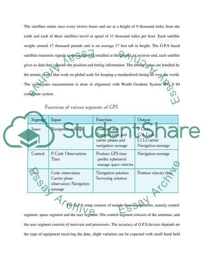
The satellites rotate once every twelve hours and are at a height of 9 thousand miles from the earth and each of these satellites travel at speed of 11 thousand miles per hour .Each satellite weighs around 17 thousand pounds and is on average 17 feet tall in height. The G.P.S based satellites transmits signals to the equipment installed at the ground, at receiver end, each satellite gives us data that contains the position and timing information .The timing issues are handled by the atomic clocks that work on global scale for keeping a standardized timing all over the world.

The coordinates measurement is done in alignment with World Geodetic System WG S 84 coordinate system. The G.P.S setup consists of mainly three components, namely control segment, space segment and the user segment .The control segment consists of the antennas, and the user segment consists of receivers and processors .The accuracy of G.P.S devices depends on the type of equipment receiving the data, slight variation can be expected with small hand held devices up to 10 to 20 meters. However, advanced methods like Differential G.P.S helps improving the efficiency in results .

For commercial use two signals are generated L1, and L2, which operates in the frequency range of 1575.42 MHz in the Ultra High Frequency spectrum. In modern times G.P.S is used in almost all activities of life. This includes the use for military purposes and civilian use in prime. So much so, at times the people acquainted from the court case on parole are traced through global navigation system . In case of Military, G.P.S is used in radars, missile systems, fighter planes, on foot soldiers during the war.

In commercial field G.P.S finds large number of uses, G.P.S can be largely found in the cars these days, in commercial aero planes, they find large users in the field of agriculture, where places are less accessible, these navigation means can help reaching out all those areas. Global Navigation systems are of large use in disaster situations, floods, tornados, tsunamis, earthquakes, parts of land that are disconnected from rest of the area can be accessed and people stranded can be easily rescued by locating their position through G.P.S .

Through use of Aerial means, the ground situation can be determined and further strategy can be analyzed .Weather predictions are made possible through the satellites that are out in the open. And hence weather forecasts advancements can be attributed to the use of satellite advancements and navigation setups. G.P.S finds large application in the field of engineering; it has space for software engineering, the aerospace engineers, and hardware engineering. It is a known fact that every technology has its uses and abuses and global navigation system like all other inventions can be exploited in few cases, its use in some cases can be termed as privacy violation because it can make its way through the garages of any area in any part of the world.

Factors like G.P.S data editing, signal spoofing and alias creation of signal can be a weakness in terms of its use for different purposes. Breach in privacy violations can be taken as serious offence by different organizations and individuals, however all the data so collected mostly remains safe in the hands of administrators. Lack of Cryptographic protection of all the data collected is considered as a weakness in the overall system .Further admissibility of G.P.S data in the court of law is another subject of consideration.

Another serious issue concerning the proper use of global positioning systems is the monitoring and sky touring of the defense installations of various countries, along with other important places. These all count as vulnerabilities of the incumbent, special mechanism must be devised in order to overcome these issues and make G.P.S a total safe and secure technological means that cannot be used in any destructive way. In military use, the global navigation systems are used against the enemy in identifying and tracing the important positions of the enemy’s strategic places.

Bibliography: (1).El-Rabbany, A. (2002). Introduction to GPS: The Global Positioning System. Boston, MA: Artech House. (2). McNamara, Joel. (2004). GPS For Dummies174. Wiley. (3). Pace, S., Frost, G., Lachow, I., Frelinger, D., Fossum, D., & RAND CORP SANTA MONICA CA. (1995). The Global Positioning System: Assessing National Policies. Ft. Belvoir: Defense Technical Information Center. (4). GPS Basics,Introduction to the system. Switzerland.by Jean-Marie_Zogg_ (5). Finz, S. & Taylor, M. (2004).

Peterson tracking device called flawed, Defense wants GPS evidence shut out of trial. San Francisco Chronicle. Retrieved October 4, 2007,

Read More
Tags
Cite this document
  • APA
  • MLA
  • CHICAGO
(“Global Navigation System Lab Report Example | Topics and Well Written Essays - 750 words”, n.d.)
Global Navigation System Lab Report Example | Topics and Well Written Essays - 750 words. Retrieved from https://studentshare.org/engineering-and-construction/1438479-global-navigation-system
(Global Navigation System Lab Report Example | Topics and Well Written Essays - 750 Words)
Global Navigation System Lab Report Example | Topics and Well Written Essays - 750 Words. https://studentshare.org/engineering-and-construction/1438479-global-navigation-system.
“Global Navigation System Lab Report Example | Topics and Well Written Essays - 750 Words”, n.d. https://studentshare.org/engineering-and-construction/1438479-global-navigation-system.
  • Cited: 0 times

CHECK THESE SAMPLES OF Global Navigation System

Electronic Chart Display and Information System

Electronic Chart Display and Information system (ECDIS) has been in vogue in shipping industry for about two decades now.... ECDIS is also an information system.... he data in the system Electronic Nautical Chart (SENC) is generated from the original data of the ENC.... Electronic Chart Display and Information system (ECDIS) has been in vogue in shipping industry for over two decades now.... However it is in shipping that the system is widely used and we shall restrict our discussion to the electronic nautical charts....
9 Pages (2250 words) Essay

Website development.The recommended activities. Part 4

What are the major sections These are excellent candidates for the Global Navigation System, which appears on every page of the site and enables users to quickly jump between sections.... A well-designed structure makes it easy to define a navigation system, and the two together make designing page layouts and templates a snap.... A well-designed structure makes iteasy to define a navigation system, and the two together make designing page layouts and templates a snap....
2 Pages (500 words) Essay

The Future of Automatic Identification System

ifferential GNSS services: It makes use of differential navigation techniques combined with GLONASS and GPS, collectively referred to as global navigation Satellite Service (GNSS).... hellip; A shipping firm is therefore concerned with the question of how the firm or the ship can minimize the cost of producing each ton-mile, given the price (reward) of each factor of production. Automatic Identification system (AIS) is an effort towards ensuring the safety and thus increasing the level of production....
9 Pages (2250 words) Essay

Global Navigation Satellite System

osition, Velocity and Time Service (PVT)Accuracy and Integrating Services (AI)Ranging and Timing Services (RT)High Integrity Services (HI)PoliticsThere is an opposition to the European 'Galileo' GNSS mainly from GPS who want to be the sole satellite navigation system.... The paper “global navigation Satellite System” discusses GNSS, a system based on advanced technology capable of position determination of an individual or an object in space and time....
2 Pages (500 words) Essay

Federal Radio-Navigation Plan

As FRP comprises of five sections, namely, Introduction, Roles and Responsibilities, Policy, Radio-navigation system User Requirements, and Operating Plans.... In addition, FRP is used for providing planning schedules and information pertaining to the US Government (USG) radio-navigation system.... While providing a platform for user-input, FRP is meant to clarify unresolved common issues related to the radio-navigation system.... Nationwide Differential GPS system (NDGPS) is a ground-based augmentation system, which is managed by Federal Railroad Administration, US Coast Guard and Federal Highway Administration, meant to provide increased accuracy to specific users....
5 Pages (1250 words) Assignment

Hospital Patient Navigator

Patient navigators are individuals that assist the patients in the healthcare system to improve access and understanding for sever sufferers of cancer.... Evaluating the cost and impact of navigation requires the use of a novel method that is critical in The populations with limited access on the healthcare system encounter difficulty in using the system leading to delay in cancer diagnosis, added costs, less efficient, and effective use of recommended therapies....
4 Pages (1000 words) Research Paper

Performance-Based Navigation

These advancements guide us to ground-breaking uses of new technologies to fulfill the needs of the public for a comfortable, safer and more efficient/effective air transportation system.... From the paper "Performance-Based navigation" it is clear that the Next Generation execution Plan has a solid, fully-funded promise to new ready abilities, new airport transportation, and bitterness in the safety, security, and environmental performance.... We will discuss performance-based navigation and its issues in the details....
10 Pages (2500 words) Research Paper

Evaluation of Unmanned Aerial Vehicles

The paper "Evaluation of Unmanned Aerial Vehicles" states that it has become easier to evaluate rescue operations since these vehicles can be automated at various sites to assess the situations on the ground.... Below is an evaluation of the uses of UAVs.... hellip; UAV technologies are broadly underused in many parts of the world....
8 Pages (2000 words) Essay
sponsored ads
We use cookies to create the best experience for you. Keep on browsing if you are OK with that, or find out how to manage cookies.
Contact Us