StudentShare
Contact Us
Sign In / Sign Up for FREE
Search
Go to advanced search...
Free

Earthquake Dangers to the California State East Bay Campus - Research Paper Example

Cite this document
Summary
The paper "Earthquake Dangers to the California State East Bay Campus" discusses that when the earthquake of large magnitude is imminent in Hayward, it requires having a good preparedness to reduce the loss of life, economic disruption, personal injuries and property loss…
Download full paper File format: .doc, available for editing
GRAB THE BEST PAPER92.7% of users find it useful
Earthquake Dangers to the California State East Bay Campus
Read Text Preview

Extract of sample "Earthquake Dangers to the California State East Bay Campus"

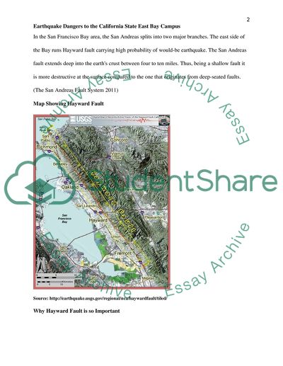
Earthquake Dangers to the California East Bay Campus Introduction San Francisco Bay area is considered most sensitive to the earthquake as about 100 kilometers long faultline passes through it in the Earths crust. In 1868, the earthquake with magnitude of nearly 7.0 struck around Hayward faultline and considered to be the most destructive one in the California history. As per USGS scientist, the Hayward fault can crack anytime from now and cause a powerful earthquake of the same or higher magnitude. The impending earthquake can cause a huge loss of life in the region. (Alden, 2010) San Andreas Fault–A Main Source of Earthquake San Andreas Fault is a main source of earthquake and it is roughly 625 miles long and passes through California, U.S. The fault is a strike-slip fault and located between the North American Plate and Pacific Plate. Land on the west side of the fault is moving gradually to the northwest while the land on the east side of the fault is moving toward southwest side. This movement is found to be 0.2 inch per year. (Alden, 2010) The study of San Andreas Fault is important from the view point of earthquake science. Californias rich mineral wealth and unusual landscape is due to this fault. The earthquakes along this fault line have affected people enormously and have taught people how to prepare for natural disasters. (Alden, 2010) Relationship between San Andreas Fault and Hayward Fault The San Andreas Fault is not a single break fault. It has several major and minor branches in southern California. The fault is a longest of its kind in the world. Starting from Point Arena, north of San Francisco it ends at Salton Sea covering distance of almost 625 miles. In the San Francisco Bay area, the San Andreas splits into two major branches. The east side of the Bay runs Hayward fault carrying high probability of would-be earthquake. The San Andreas fault extends deep into the earths crust between four to ten miles. Thus, being a shallow fault it is more destructive at the surface compared to the one that originates from deep-seated faults. (The San Andreas Fault System 2011) Map Showing Hayward Fault Source: http://earthquake.usgs.gov/regional/nca/haywardfault/tiled/ Why Hayward Fault is so Important From Fremont to San Pablo Bay running almost 40 miles, the Hayward Fault passes beneath the surface of the most densely populated regions of the California State. It is estimated that two million people stay and work along the faultline. Schools, gas lines, trauma centers and many other establishments are located near the fault. A powerful earthquake of the magnitude 7 or above along the Hayward fault may occur any time in next 30 years making a colossal loss in North California. Geologists have found deformed curbs and cracked lines in areas near the fault giving evidence of creep. Major earthquake along the line had occurred almost 140 years back and that is the usual frequency of a major earthquake along this faultline. That is how Hayward fault in this region has gained special importance among the geologists (Bay Area Faults and Earthquake …2008). The Study of Fault Fault activity is studied using seismographs that help to know about the fault behavior patterns. The study of sediments is done by digging tranches across the fault line. The study done at hundreds of places provides a detailed earthquake history. It has been found that major event on the fault occur almost every 150 years though large uncertainty prevails. The California Geological Survey has been actively studying and mapping states major faults including the Hayward fault. It maps two major hazards: liquefaction, and landlslides. Liquefaction indicates loss of strength of land due to shaking and that may cause buildings to fall. Landslides may take place where steep slopes are there either along riverbank or in the hills. (Alden 2010) Fault Types Fault has caused complex geology and diverse landscape in California. Many underground traps are created by faulting and that has helped construct huge reservoirs of crude oil, water, or precious metal ores. A following map shows various branches of fault across San Andreas Fault. Source: http://www.consrv.ca.gov/cgs/information/publications/teacher_features/Pages/faults.aspx Fault can be classified depending upon the movements of rocks on both sides. Dip-Slip Movement If the movement of rocks on both side of the fault is an up or down type then it is known as dip-slip movement. Source: http://www.consrv.ca.gov/cgs/information/publications/teacher_features/Pages/faults.aspx The Sierra Nevada fault zone is the example of such fault. (California Geological Survey 2007) Strike-Slip Movement If the rocks on each side of the fault make a sideways movement then it is known as strike-slip movement. In strike-slip fault rocks move in parallel passing each other. The San Andreas is an example of strike-slip fault displacing rocks up to tens and hundreds of miles. The horizontal movement causes rocks of different composition to place side by side. Furtehr, the San Andreas Fault is composed of several minor and major faults, this kind of movement may occur anywhere along the faultline. (California Geological Survey 2007) Source: http://www.consrv.ca.gov/cgs/information/publications/teacher_features/Pages/faults.aspx Previous Earthquakes along the Hayward Fault Dating the soils across a fault is a technique used to find the past history of the Hayward fault. This determines how often the earthquakes have occurred in the past and its magnitude. Geologists do various observations such as fault trenches, geomorphic expression and fault creep (Urbanization of the Hayward Fault 2010). New Findings along the Hayward Fault The two terms recurrence interval and seismic gap are meaningful from the standpoint of happening of earthquakes which can be defined as per the following. Recurrence Interval The recurrence interval is defined as the average time period between two large earthquakes at a specific site. (Recurrence Interval 2009) Seismic gap A locked fault area that is free from any seismic activity for a long time. No earthquakes have been observed in certain seismic gaps. They have potential to cause big earthquakes as stress accumulates in seismic gaps. (Seismic gap 2009) The US Geological Survey has warned the occurrence of big earthquake anytime along the Hayward Fault as it has completed 140 years since the last major earthquake happened in 1868. New results of age-dating studies, imagery of deformation and creep, 3-D geometric as well as mechanical models indicate about a repeat event of the equal magnitude. Data obtained from the studies suggest that the average interval time of 10 earthquakes before 1868 was 170 years; however, last five of these had occurred at a time gap of 140 years. During these years the population in the region has increased several fold and so the risk to the people in the area. A 3-D geological model has been used to understand the Hayward-Calaveras fault junction. Deep seismicity has suggested linkages between Calaveras and Hayward faults and together they can generate an earthquake of magnitude higher than 7. Recent 3-D geologic mapping and relocations of earthquakes have indicated that the fault geology and geometry at depths is different than found at the surface. The inference of these studies now treats the Calaveras and Hayward faults as a single unit. This certainly places San-Francisco Bay region at high risk. (Californias Hayward Fault Revealed 2007) Hayward Mitigation Plan When earthquake of large magnitude is imminent in Hayward, it requires having a good preparedness to reduce the loss of life, economic disruption, personal injuries and property loss. In last three decades following series of actions have been taken to mitigate the effects of earthquake in Hayward city and region through the funding from Federal Emergency Management Agency (FEMA). In 1986, California State enacted a law that required all communities to register potentially hazardous Unreinforced Masonry buildings before January 1990. In 1987, Hayward created a Mitigation Task Force to find seismically hazardous buildings and in all 282 such buildings were found. In 1990, Mitigation Task Force was asked to submit recommendations to city authorities. Based on the recommendation of task force, Hayward City Council retrofits all tilt-up buildings and other hazardous buildings at the total estimated cost of $15 million. State enacted Public Building Rehabilitation Bond Act of 1990 under which Hayward received 7 grants of greater than $2 million. (Porter 2000) With the help of FEMA grants wastewater treatment plant and seismically hazardous fire stations were constructed or retrofitted. It has been observed that Hayward has gone beyond the States URM requirement– establishing a voluntary program providing financial incentives so that people can do the retrofitting job privately. There was no opposition to the programs from the residents of Hayward and FEMA mitigation grants helped Hayward to develop its own mitigation program successfully. (Porter 2000) Conclusion Earthquakes are natural calamities that cannot be avoided; however, recent advances in science and technology have helped us to understand and predict its occurrence so that loss of life and damages to the property in the area could be largely averted. Earthquake mitigation plans undertaken in Hayward and other places will ensure that this time people are saved off from devastating effects of earthquake. References 1. Alden, A (2010); About the Hayward Fault of California, online from December 2, 2011, http://geology.about.com/od/geology_ca/tp/abouthaywardfault.htm 2. The San Andreas Fault System (2011), San Diego State University, online from December 2, 2011, http://www.sci.sdsu.edu/salton/San%20AndreasFaultSyst.html#top 3. Active Traces of the Hayward Fault (2009), U.S. Geological Survey, online from December 2, 2011, http://earthquake.usgs.gov/regional/nca/haywardfault/tiled/ 4. Bay Area Faults and Earthquake Educator Guide (2008), online from December 2, 2011, http://science.kqed.org/quest/files/imp/Radio3_2BAFaultsandEarthquakes.pdf 5. San Andreas Fault (2009), online from December 2, 2011, http://www.sciencedaily.com/articles/s/san_andreas_fault.htm 6. Urbanization of the Hayward (2010), online from December 2, 2011, Faulthttp://earthquake.usgs.gov/regional/nca/1868virtualtour/fault.php 7. California Geological Survey (2007), online from December 2,2011, http://www.consrv.ca.gov/cgs/information/publications/teacher_features/Pages/faults.aspx 8. Californias Hayward Fault Revealed (2007), Sciencedaily, online from December 2, 2011, http://www.sciencedaily.com/releases/2007/12/071214001612.htm 9. Recurrence Interval (2009), Earthquake Glossary, online from December 2, 2011, http://earthquake.usgs.gov/learn/glossary/?term=recurrence%20interval 10. Seismic gap (2009), Earthquake Glossary, online from December 2, 2011, http://earthquake.usgs.gov/learn/glossary/?term=seismic gap 11. Porter, K (2000), Mitigation saves: FEMA Spent $3.5B and Saved $14B, online from December 2, 2011, http://www.earthquakeconference.org/Presentations/Porter%20Mitigation%20Saves_NEC%2008.pdf Read More
Cite this document
  • APA
  • MLA
  • CHICAGO
(Earthquake Dangers to the California State East Bay Campus Research Paper, n.d.)
Earthquake Dangers to the California State East Bay Campus Research Paper. Retrieved from https://studentshare.org/geography/1762443-geology
(Earthquake Dangers to the California State East Bay Campus Research Paper)
Earthquake Dangers to the California State East Bay Campus Research Paper. https://studentshare.org/geography/1762443-geology.
“Earthquake Dangers to the California State East Bay Campus Research Paper”, n.d. https://studentshare.org/geography/1762443-geology.
  • Cited: 0 times

CHECK THESE SAMPLES OF Earthquake Dangers to the California State East Bay Campus

Dangerous and Natural Energy

The neighboring areas and borders of Kentucky, Arkansas and Tennessee in the southern part, the california coast and an area in the Wyoming/Idaho area are more at risk than the other parts of the country.... california followed by Oregon in the second place is the most risky from the point of view of an earthquake occurrence.... Washington is not too far behind of having a likelihood of facing earthquake as well as few regions in Idaho, Nevada, Utah and Arizona according to the National seismic hazard map....
4 Pages (1000 words) Essay

The Causes of a Societal Problem in the Bay Area of California

Name Institution Instructor Course Date The causes of a societal problem in the bay Area of California Introduction The San Francisco surrounds the San Francisco area in Northern California characterized by dense population.... Ideally, this bay has one of best infrastructural systems in the United States of America as its interstate connection is by good roads and fast railway transport (Dyble 266).... In this regard, this paper will dwell on the causes of the societal issue that the bay region experiences that opposes its success....
4 Pages (1000 words) Essay

Decision Support Systems

 This paper discusses the situation on October 8, 2005 a major earthquake, measuring 7.... hellip;  Even after the earthquake is struck there are possibilities of evacuating the people from the affected areas, which should be done with the help of the army and the air force.... Further, changes in demography and climate could lead to more damages (Pakistan 2005 earthquake, n.... , 24)Decision Support Systems: Considering the extent of the devastation caused by the earthquake in Pakistan and the possibility of its reoccurrence in the future, it is necessary that certain strategy should be devised to reduce the deadly effects of these natural catastrophes....
4 Pages (1000 words) Term Paper

Dangerous and Natural Energy

The farther east an individual goes in the United States, with the exception of the red area on the Tennessee border, the less likely of an earthquake occurrence.... california, Nevada, and Washington are the highest risk states.... This indicates I live in an area that could have a major earthquake in the next fifty years, but the odds are against it.... Texas, Florida, Minnesota, North Dakota, Wisconsin and Michigan have the lowest chance of having a major earthquake in the next fifty years....
3 Pages (750 words) Essay

Dangerous and Natural Energy

SGS interactive map can also be used by both the federal and state agencies to regulate and control development and construction of property such as buildings within some areas with regard to.... According to the earthquake patterns in the USGS interactive map, it is evident that most of the seismic hazard areas in the United States are distributed along the Pacific Coast from the North Western states such as the coast of Washington, Oregon, and california, as well as in the regions of Alaska and Hawaii....
3 Pages (750 words) Essay

Epicenter and Magnitude of the Earthquake

The paper “Epicenter and Magnitude of the earthquake” seeks to explore seismic waves, which refer to waves of an earthquake.... These waves come about as the energy released decapitated by an earthquake moves from one point within the earth to another.... hellip; The author states that the seismograph refers to an instrument used to record the seismic waves of the earthquake.... The focus is the point that an earthquake originates and the epicenter is the point of the surface of the earth perpendicularly above the focus....
1 Pages (250 words) Assignment

California State and Local Government

The funding restoration order to some agencies and programs is done by the california Supreme Court.... Legislative campaign funds are controlled by the california legislature.... hapter 6Identify and discuss the different aspects of the california Judicial Branch and the Federal Government's Judicial Branch.... Therefore, the california government needs to stop fighting because of fiscal resources and focus on the main problems that plague the state to resolve budget issues....
1 Pages (250 words) Essay

The Potential Effects of a Large Earthquake

It is located on the east side of San Francisco bay running through Fremont and 3700 peril lane, San José city.... This fault lies parallel to san Andrea's fault on the west side and to its east side is the Calaveras fault.... Earthquake hazard mapping is mainly used in california in efforts to ensure that there is effective land use.... The essay "The potential effects of a large earthquake" discusses the possible areas to move in, their main good and disruptive factors....
4 Pages (1000 words) Essay
sponsored ads
We use cookies to create the best experience for you. Keep on browsing if you are OK with that, or find out how to manage cookies.
Contact Us