StudentShare
Contact Us
Sign In / Sign Up for FREE
Search
Go to advanced search...
Free

An historical perspective on this surveying process for (levelling survey) - Essay Example

Cite this document
Summary
Leveling is a surveying technique that involves the measurement of geodetic height using a digital level, dumpy level, spirit level, or a laser level. The objective of leveling is to locate the elevation of a given point relating to the given or assumed datum, and to…
Download full paper File format: .doc, available for editing
GRAB THE BEST PAPER99% of users find it useful
An historical perspective on this surveying process for (levelling survey)
Read Text Preview

Extract of sample "An historical perspective on this surveying process for (levelling survey)"

SURVEYING: LEVELING Leveling Survey Leveling is a surveying technique that involves the measurement of geodetic height using a digital level, dumpy level, spirit level, or a laser level. The objective of leveling is to locate the elevation of a given point relating to the given or assumed datum, and to establish a point at a given elevation regarding the given or assumed datum (Cazanescu and Mudura, 2010, 471). Leveling is a historical procedure that surveyors have conducted over the years using techniques such as barometric, differential, and trigonometric.

There are several older style optical instruments such as the wye level. Most of the older versions were bulky and involved tedious measurements and data collection. In addition, the telescopes were low-powered as compared to newer versions that are more powerful. Later on, William Grant, an English civil engineer developed the dumpy level, which was more compact and portable. Its disadvantage is the requirement of shorter sights, which means that one has to make several sights. Surveyors used precise level designs, which had a micrometer adjustment to raise or lower the line of sight and an extremely precise spirit level tube, in large leveling projects that demanded accurateness.

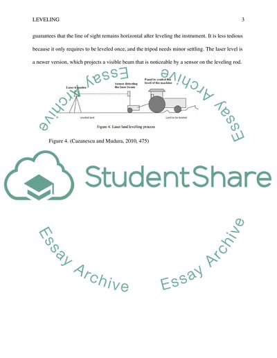
Even so, the automatic level revolutionized leveling because it guarantees that the line of sight remains horizontal after leveling the instrument. It is less tedious because it only requires to be leveled once, and the tripod needs minor settling. The laser level is a newer version, which projects a visible beam that is noticeable by a sensor on the leveling rod.Figure 4. (Cazanescu and Mudura, 2010, 475) List of ReferencesCAZANESCU, S. and MUDURA, R., (2010), Modern Technology for Land Levelling, Based On A 3d Scanner, Research Journal of Agricultural Science, 42 (3), 2010.

Read More
Tags
Cite this document
  • APA
  • MLA
  • CHICAGO
(“An historical perspective on this surveying process for (levelling Essay”, n.d.)
Retrieved from https://studentshare.org/engineering-and-construction/1684824-an-historical-perspective-on-this-surveying-process-for-levelling-survey
(An Historical Perspective on This Surveying Process for (levelling Essay)
https://studentshare.org/engineering-and-construction/1684824-an-historical-perspective-on-this-surveying-process-for-levelling-survey.
“An Historical Perspective on This Surveying Process for (levelling Essay”, n.d. https://studentshare.org/engineering-and-construction/1684824-an-historical-perspective-on-this-surveying-process-for-levelling-survey.
  • Cited: 0 times

CHECK THESE SAMPLES OF An historical perspective on this surveying process for (levelling survey)

Psychographic Segmentation of Potential Customers

Marketers, historically, have utilised geographic and demographic characteristics as the primary basis behind the division of consumers into viable market segments (Boone & Kurtz, 2006).... Many businesses have found success through these rather traditional marketing efforts.... hellip; r, as contemporary consumers become more sophisticated and complex markets, the need for fuller, more realistic portraits of consumer lifestyles is becoming more prevalent for todays marketers....
8 Pages (2000 words) Essay

GPS And Its Use In Modern Surveying

The paper "GPS And Its Use In Modern surveying" discusses the benefits from the use of GPS.... GPS And Its Use In Modern surveying The Global Positioning System (GPS) is a system of satellite navigation that is space-based, and provides information about time and location of a region in all kinds of weathers provided that an unobstructed line of sight is present to at least four GPS satellites.... GPS has immense application in modern surveying....
1 Pages (250 words) Essay

Engineering and Construction: Surveying

The main objective of this project was to survey, analyze and take into a consideration of the current and the future use of the facility.... This engineering and construction project entails surveying, analyzing and property examination at the PSU Millar Library of the University of Portland State.... In doing this particular project, various considerations were taken to factors such as the popularity of the property,… The facility in this case is currently being used in accordance to its use and this therefore means that improvements in the property will help in increasing the usefulness and the functionality to the public. The main 6/6 Engineering and Construction (surveying) This engineering and construction project entails surveying, analyzing and property examination at the PSU Millar Library of the University of Portland State....
2 Pages (500 words) Essay

Professionalism and Ethics in Surveying

The ethical conduct for a professional surveyor thus dictates that licensees shall engage in the practice of conducting land survey in an ethical manner while at the same time being familiar with the appropriate and recognized codes of the land surveying ethics.... Corner monuments are the parcels or lines of easements that are only possible to visualize on the ground through setting markers or with aid of survey monuments.... The aim of the paper “Professionalism and Ethics in surveying” is to analyze people acting in ethical manner....
4 Pages (1000 words) Essay

The Use of Surveying in Mapping Features within the Physical Landscape

plane table survey set-up consists of a drawing platform, a tripod, an alidade, and a device for measuring distances (Gillespie 1868; McCormac 2004).... "The Use of Surveying in Mapping Features within the Physical landscape" paper focuses on morphological mapping which is the process of delineating different features in a landscape based on their surface form or morphology....
6 Pages (1500 words) Term Paper

Surveying Integral Processes

"surveying Integral Processes" paper argues that surveying is a very complex procedure that involves a lot of care, accuracy, and effort.... It is safe to conclude that surveying requires great mathematical and analytic skills which not too many people possess.... nbsp; The elevation is another common surveying term that refers to the height which is usually above sea level.... rchitecture and trigonometry go hand in hand; it has several major uses when it comes to surveying sites and determining solutions to various arduous problems....
9 Pages (2250 words) Coursework

Building Components and Types

he Design process and the Main Principal Requirements of a ProjectDesign ProcessIn building construction, the first step in the design process is creating a schematic design, which means developing simple diagrammatic documents outlining room sizes and relationships.... After the schematic design has been reviewed and approved by the building committee, the design team will then submit as a final stage of the design process, drawings, project narrative, and estimate of the construction cost for building committee approval (College of DuPage, 2011, p....
10 Pages (2500 words) Term Paper

Surveying - Dilidtins Process in Property

Consequently, the surveyor has an influential part to play in the dilapidations process.... This paper reviews the role of surveyors in this process, with particular reference to the uncertainty and variability of the surveyor's judgments and decision-making.... They should also be able to identify and diagnose faults with design issues, construction methodology, and materials; and be able to carry out the building inspection and assessment process from the foundations until completion....
11 Pages (2750 words) Assignment
sponsored ads
We use cookies to create the best experience for you. Keep on browsing if you are OK with that, or find out how to manage cookies.
Contact Us