StudentShare
Contact Us
Sign In / Sign Up for FREE
Search
Go to advanced search...

Understanding Geospatial Data in Development - Assignment Example

Cite this document
Summary
The coastline of Bangladesh is endowed with a confluence of sediments in the low altitude alluvial and delta plains from the Ganges and Brahmaputra rivers. This area has a large population of over 140 million people and has recently been identified as the most risky place in the…
Download full paper File format: .doc, available for editing
GRAB THE BEST PAPER93.5% of users find it useful
Understanding Geospatial Data in Development
Read Text Preview

Extract of sample "Understanding Geospatial Data in Development"

Download file to see previous pages

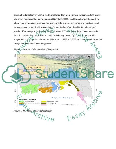
A band ratio approach can be used by diving band 5 by band 2 in order to separate the water line from the clouds. The rate of change of the coastline can be calculated for transects greater than 16000 and generated at intervals of 50 m along the coastline and the main islands. This can be done using the End point Rate technique in the Digital Shoreline Analysis System in ArcGIS. Bangladesh is located at the mouth of Brahmaputra and Ganges which are the two largest rivers in the world flowing from the Himalayas.

A large part of the country is located in the Bengal basin which is an extensive geosyncline and has a large population of about 14.2 million people. Most people live in the low lying plains floodplains and delta plains which are usually very vulnerable to flooding during the monsoon season (Alesheikh et al, 2007). As a result, Bangladesh is normally considered as one of the most risky countries in the world due to exposure to the effects of climate change and sea level rises. The coastline of Bangladesh covers an area of about 47,201square kilometers and this region is inhabited by about 46 million people.

River Ganges drains about 1114000 square kilometers of catchment area and the River Brahmaputra drains 935000 square kilometers of catchment area and these supplies billions of tonnes of sediments every year in the Bengal basin. This rapid increase in sedimentation results into a very rapid accretion in the estuaries (Goodbred, 2003). In other sections of the coastline where rapid erosion is experienced due to strong tidal currents and strong waves action, rapid subsidence can be noted with a recession of about 3-4 km of the shoreline from its original position.

If we compare the Landsat images between 1973 and 2000, the recession rate of the shoreline and the time frame can be established (Benny, 2000). By comparing the satellite images

...Download file to see next pages Read More
Cite this document
  • APA
  • MLA
  • CHICAGO
(“Understanding Geospatial Data in Development Assignment”, n.d.)
Understanding Geospatial Data in Development Assignment. Retrieved from https://studentshare.org/geography/1682047-understanding-geospatial-data-in-development
(Understanding Geospatial Data in Development Assignment)
Understanding Geospatial Data in Development Assignment. https://studentshare.org/geography/1682047-understanding-geospatial-data-in-development.
“Understanding Geospatial Data in Development Assignment”, n.d. https://studentshare.org/geography/1682047-understanding-geospatial-data-in-development.
  • Cited: 0 times

CHECK THESE SAMPLES OF Understanding Geospatial Data in Development

Emergent Technology : Web 3.0

is a combination of 3D Web, geospatial The single biggest attraction that could be drawn from Web 3.... What these processes entail is a fact related with the building up of the databases, accessibility of content through the use of non-browser programs and… There is also the relation of artificial intelligence technologies which are embedded within Web 3....
4 Pages (1000 words) Essay

A statement of purpose Graduate school

ne of the most important uses of GIS is to exploit the geospatial data in emergency situations.... The geospatial data is important resource for optimizing use of technology, communication and using it to formulate developmental policies in various areas like human resource, infrastructure, natural resources, education etc.... By bringing GIS expertise to UAE so that we could exploit our geospatial data and metadata for development.... In the current environment of advancing technology, GIS plays important role in the development of nations which is especially true for UAE where expertise in the area is the need of the hour....
2 Pages (500 words) Admission/Application Essay

Geospatial Intelligence Assessment Detailing the Washington DC Metro Station and the Power Stations

The available SIGINT and HUMINT among other intelligence reports are categorically significant in the formulation of the terrorism attack just about to be launched by the militia group of… The approaches to the North power Station of the Washington D.... .... are formulated as listed below to curb any possible leeway to the power station by the terrorist attack. Among the very busy within the vicinity of the great city of Washington is the East Capitol It's always heavy with traffic and it connects to the northwards to Kenilworth Avenue leading to the North Power Station....
6 Pages (1500 words) Essay

Geographic Information System

The rational mapping of cyber-framework has been regarded a good exercise for securing and controlling data and network assets for momentarily.... GIS technologies permit a user to proficiently analyze, produce and manage geospatial, to pool GEOINT with other methods of intelligence gathering and to achieve extremely… Consequently, GIS produces contemporary and more dependable GEOINT to minimize doubt for a decision maker (Buxbaum, p.... In the middle of a developing awareness that the geospatial facet of IT framework can play a vital role in protecting systems and networks, several companies are creating contributions that integrate those two facets....
5 Pages (1250 words) Essay

Water Shortage in New Zealand

The methodology detailed in the paper is basically about the data collection, storage, record and analysis pertaining to water shortage.... hellip; The elaboration had been done on the way the data is collected and the sources from where it was obtained.... Apart from this, the survey related to the data collection is laid down in the methodology section.... Primarily, for this purpose the analysis was done as to what will be the ideal source to collect the data....
6 Pages (1500 words) Assignment

Importance of Statistical Significance in Analyzing Quantitative Data

The paper "Importance of Statistical Significance in Analyzing Quantitative data" states that significance analysis is crucial because it may be used as a researcher's tool in gaining basic knowledge in understanding situations and events.... Significance statistical analysis gathers factual and measurable data which may be considered statistical.... This method of data analysis is commonly applicable in mathematical grounds, science, and also in businesses....
5 Pages (1250 words) Essay

GIS as a Tool to Promote Sustainable Environmental Management

In order to manage the environment and attain sustainable development, there is a need to have access to reliable and accurate data to be able to make such complex decisions.... The GIS allows geographically tied non-map data to be analyzed (Wikle 1991, p.... It mainly deals with the processing of geographical data (Patil 2012, p.... With GIS software, environmental planners can easily manage multiple types of geographical data, measure change like wildlife habitat encroachment, and model events like the impact of drought on forestation among others....
8 Pages (2000 words) Term Paper

Geographical Information System

This period was a milestone for GIS database development as its operations expanded from individual projects to corporate resources.... As technological development of GIS advanced prescriptive analysis of mapped data was adapted from the former descriptive “geo-query” database method.... Currently, GIS is considered as the most effective way of handling voluminous geographical data and is also reliable in spatial analysis capabilities.... Mapped data format has radically changed from the previous analog inked lines on paper to storage of data on disks (Ghose 2001)....
7 Pages (1750 words) Essay
sponsored ads
We use cookies to create the best experience for you. Keep on browsing if you are OK with that, or find out how to manage cookies.
Contact Us